

20170526_090728.gpx
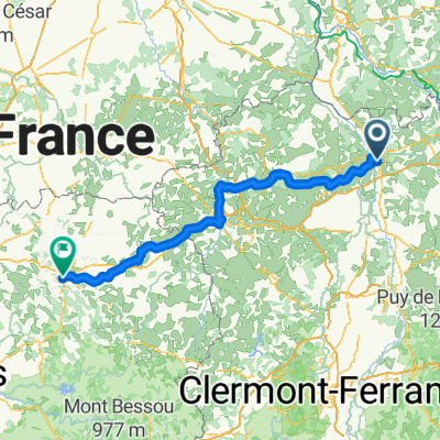
A cycling route starting in Yzeure, Auvergne-Rhône-Alpes, France.
Overview
About this route
TAHUNA track
- -:--
- Duration
- 39.2 km
- Distance
- 185 m
- Ascent
- 185 m
- Descent
- ---
- Avg. speed
- ---
- Max. altitude
Route quality
Waytypes & surfaces along the route
Waytypes
Road
12.2 km
(31 %)
Quiet road
7.8 km
(20 %)
Undefined
19.2 km
(49 %)
Surfaces
Paved
7.4 km
(19 %)
Asphalt
7.4 km
(19 %)
Undefined
31.8 km
(81 %)
Continue with Bikemap
Use, edit, or download this cycling route
You would like to ride 20170526_090728.gpx or customize it for your own trip? Here is what you can do with this Bikemap route:
Free features
- Save this route as favorite or in collections
- Copy & plan your own version of this route
- Sync your route with Garmin or Wahoo
Premium features
Free trial for 3 days, or one-time payment. More about Bikemap Premium.
- Navigate this route on iOS & Android
- Export a GPX / KML file of this route
- Create your custom printout (try it for free)
- Download this route for offline navigation
Discover more Premium features.
Get Bikemap PremiumFrom our community
Other popular routes starting in Yzeure
 20170126_125809.gpx
- Distance
- 33.3 km
- Ascent
- 61 m
- Descent
- 56 m
- Location
- Yzeure, Auvergne-Rhône-Alpes, France
 20170320_122001.gpx
- Distance
- 56.5 km
- Ascent
- 222 m
- Descent
- 222 m
- Location
- Yzeure, Auvergne-Rhône-Alpes, France
 bourbon Lancy
- Distance
- 38.7 km
- Ascent
- 242 m
- Descent
- 242 m
- Location
- Yzeure, Auvergne-Rhône-Alpes, France
 Paco 7
- Distance
- 173.2 km
- Ascent
- 1,820 m
- Descent
- 1,574 m
- Location
- Yzeure, Auvergne-Rhône-Alpes, France
 .gpx
.gpx- Distance
- 40 km
- Ascent
- 183 m
- Descent
- 186 m
- Location
- Yzeure, Auvergne-Rhône-Alpes, France
 20170203_103257.gpx
- Distance
- 34 km
- Ascent
- 131 m
- Descent
- 134 m
- Location
- Yzeure, Auvergne-Rhône-Alpes, France
 20170621_060924.gpx
- Distance
- 47.3 km
- Ascent
- 105 m
- Descent
- 105 m
- Location
- Yzeure, Auvergne-Rhône-Alpes, France
 20170307_090803.gpx
- Distance
- 31.7 km
- Ascent
- 110 m
- Descent
- 113 m
- Location
- Yzeure, Auvergne-Rhône-Alpes, France
Open it in the app