

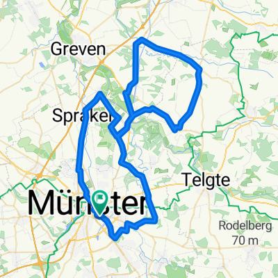
Münster-Glandorf-Bad Iburg
A cycling route starting in Münster, North Rhine-Westphalia, Germany.
Overview
About this route
Schöne Tour, ca.60 km, viel Natur, bei Glandorf gibts die Heideseen ( Naturschutzgebiet). Hält aber zum verweilen an. Übernachtung in Bad Iburg, Bett and Bike Hotel Altes Gasthaus Fischer-Eymann sehr zu empfehlen
- -:--
- Duration
- 58.6 km
- Distance
- 123 m
- Ascent
- 60 m
- Descent
- ---
- Avg. speed
- ---
- Avg. speed

Route photos


Route quality
Waytypes & surfaces along the route
Waytypes
Quiet road
29.6 km
(51 %)
Path
9.5 km
(16 %)
Surfaces
Paved
45.3 km
(77 %)
Unpaved
7.5 km
(13 %)
Asphalt
38.1 km
(65 %)
Gravel
6.1 km
(10 %)
Continue with Bikemap
Use, edit, or download this cycling route
You would like to ride Münster-Glandorf-Bad Iburg or customize it for your own trip? Here is what you can do with this Bikemap route:
Free features
- Save this route as favorite or in collections
- Copy & plan your own version of this route
- Sync your route with Garmin or Wahoo
Premium features
Free trial for 3 days, or one-time payment. More about Bikemap Premium.
- Navigate this route on iOS & Android
- Export a GPX / KML file of this route
- Create your custom printout (try it for free)
- Download this route for offline navigation
Discover more Premium features.
Get Bikemap PremiumFrom our community
Other popular routes starting in Münster
 MS 01
MS 01- Distance
- 35.9 km
- Ascent
- 48 m
- Descent
- 46 m
- Location
- Münster, North Rhine-Westphalia, Germany
 Erste Münsterland Giro.2011 Erkundungstour
- Distance
- 66.9 km
- Ascent
- 54 m
- Descent
- 54 m
- Location
- Münster, North Rhine-Westphalia, Germany
 Giro 2011 - 110 km Strecke
- Distance
- 111.7 km
- Ascent
- 238 m
- Descent
- 235 m
- Location
- Münster, North Rhine-Westphalia, Germany
 Baumbergekurztrip
- Distance
- 54.4 km
- Ascent
- 207 m
- Descent
- 208 m
- Location
- Münster, North Rhine-Westphalia, Germany
 MS-Rieselfelder-Telgte-MS
- Distance
- 52 km
- Ascent
- 99 m
- Descent
- 99 m
- Location
- Münster, North Rhine-Westphalia, Germany
 Hohe Ward Rundweg
- Distance
- 36.9 km
- Ascent
- 49 m
- Descent
- 48 m
- Location
- Münster, North Rhine-Westphalia, Germany
 Samstagnachmittagsrunde: 117 km Teuto/Schafberg
- Distance
- 117.5 km
- Ascent
- 635 m
- Descent
- 651 m
- Location
- Münster, North Rhine-Westphalia, Germany
 Münster - Telgte - Münster
- Distance
- 39.6 km
- Ascent
- 43 m
- Descent
- 44 m
- Location
- Münster, North Rhine-Westphalia, Germany
Open it in the app