

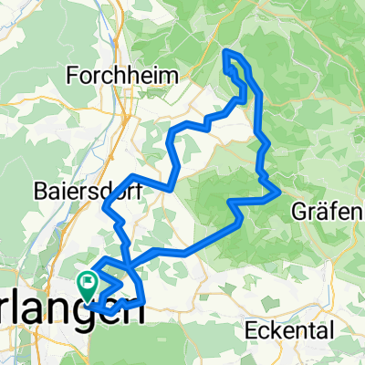
MTB Erlangen to Kalchreute
A cycling route starting in Buckenhof, Bavaria, Germany.
Overview
About this route
Single track through woods to Kalchreute and back
- -:--
- Duration
- 32.9 km
- Distance
- 228 m
- Ascent
- 230 m
- Descent
- ---
- Avg. speed
- ---
- Max. altitude

Route photos


Continue with Bikemap
Use, edit, or download this cycling route
You would like to ride MTB Erlangen to Kalchreute or customize it for your own trip? Here is what you can do with this Bikemap route:
Free features
- Save this route as favorite or in collections
- Copy & plan your own version of this route
- Sync your route with Garmin or Wahoo
Premium features
Free trial for 3 days, or one-time payment. More about Bikemap Premium.
- Navigate this route on iOS & Android
- Export a GPX / KML file of this route
- Create your custom printout (try it for free)
- Download this route for offline navigation
Discover more Premium features.
Get Bikemap PremiumFrom our community
Other popular routes starting in Buckenhof
 Lillachtal
- Distance
- 45.9 km
- Ascent
- 286 m
- Descent
- 285 m
- Location
- Buckenhof, Bavaria, Germany
 RM-MTB__Erlangen-Oedenberg_Einfach__43Km
- Distance
- 43.7 km
- Ascent
- 301 m
- Descent
- 301 m
- Location
- Buckenhof, Bavaria, Germany
 Rennrad Tour 4
- Distance
- 75.3 km
- Ascent
- 532 m
- Descent
- 534 m
- Location
- Buckenhof, Bavaria, Germany
 Flur- und Naturdenkmale im Reichswald
- Distance
- 68.5 km
- Ascent
- 310 m
- Descent
- 315 m
- Location
- Buckenhof, Bavaria, Germany
 Erlangen Standard 20km
- Distance
- 20.3 km
- Ascent
- 144 m
- Descent
- 151 m
- Location
- Buckenhof, Bavaria, Germany
 Minderleinsmühle über Kalchreuth
- Distance
- 11 km
- Ascent
- 101 m
- Descent
- 75 m
- Location
- Buckenhof, Bavaria, Germany
 Rennrad Tour 2
- Distance
- 37.1 km
- Ascent
- 199 m
- Descent
- 187 m
- Location
- Buckenhof, Bavaria, Germany
 RM-MTB__Walberla_66Km_920Hm
- Distance
- 66.3 km
- Ascent
- 854 m
- Descent
- 854 m
- Location
- Buckenhof, Bavaria, Germany
Open it in the app