

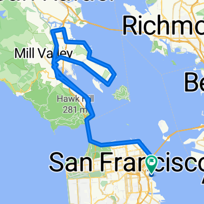
CityRide Fisherman's Wharf to Tiburon
A cycling route starting in San Francisco, California, United States.
Overview
About this route
Depart from CityRide Bike Rentals in Fisherman's Wharf, ride over the Golden Gate Bridge, through Sausalito, and finish at the ferry terminal in in the north bay town Tiburon.
- -:--
- Duration
- 31.4 km
- Distance
- 253 m
- Ascent
- 260 m
- Descent
- ---
- Avg. speed
- ---
- Max. altitude

Route quality
Waytypes & surfaces along the route
Waytypes
Cycleway
11.9 km
(38 %)
Road
6.9 km
(22 %)
Surfaces
Paved
22 km
(70 %)
Asphalt
19.1 km
(61 %)
Concrete
2.8 km
(9 %)
Undefined
9.4 km
(30 %)
Continue with Bikemap
Use, edit, or download this cycling route
You would like to ride CityRide Fisherman's Wharf to Tiburon or customize it for your own trip? Here is what you can do with this Bikemap route:
Free features
- Save this route as favorite or in collections
- Copy & plan your own version of this route
- Sync your route with Garmin or Wahoo
Premium features
Free trial for 3 days, or one-time payment. More about Bikemap Premium.
- Navigate this route on iOS & Android
- Export a GPX / KML file of this route
- Create your custom printout (try it for free)
- Download this route for offline navigation
Discover more Premium features.
Get Bikemap PremiumFrom our community
Other popular routes starting in San Francisco
 San Francisco Goldene Gate
- Distance
- 18.5 km
- Ascent
- 240 m
- Descent
- 213 m
- Location
- San Francisco, California, United States
 Presidio Promenade, San Francisco a Bridgeway, Sausalito
- Distance
- 7.2 km
- Ascent
- 120 m
- Descent
- 145 m
- Location
- San Francisco, California, United States
 paradise loop
- Distance
- 94 km
- Ascent
- 1,830 m
- Descent
- 1,827 m
- Location
- San Francisco, California, United States
 49 Mile Scenic Route
- Distance
- 81.7 km
- Ascent
- 653 m
- Descent
- 653 m
- Location
- San Francisco, California, United States
 ALC9 Thank You Ride & BBQ 2010-09-26 (RFD Actual Ride)
- Distance
- 19.8 km
- Ascent
- 294 m
- Descent
- 295 m
- Location
- San Francisco, California, United States
 Oracle Park Across the Golden Gate Bridge to Downtown Sausalito Loop
- Distance
- 39.7 km
- Ascent
- 372 m
- Descent
- 369 m
- Location
- San Francisco, California, United States
 Beach
Beach- Distance
- 19.9 km
- Ascent
- 229 m
- Descent
- 209 m
- Location
- San Francisco, California, United States
 san jose
- Distance
- 109.6 km
- Ascent
- 437 m
- Descent
- 414 m
- Location
- San Francisco, California, United States
Open it in the app