

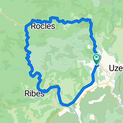
Halbe Tour am Col de Meyrand
A cycling route starting in Largentière, Auvergne-Rhône-Alpes, France.
Overview
About this route
Rauf bis zum Pass un dgleich wieder runter
- -:--
- Duration
- 28.1 km
- Distance
- 921 m
- Ascent
- 916 m
- Descent
- ---
- Avg. speed
- ---
- Max. altitude
Route quality
Waytypes & surfaces along the route
Waytypes
Road
13.8 km
(49 %)
Track
8.6 km
(31 %)
Surfaces
Paved
0.4 km
(1 %)
Unpaved
8.4 km
(30 %)
Gravel
8.4 km
(30 %)
Asphalt
0.4 km
(1 %)
Continue with Bikemap
Use, edit, or download this cycling route
You would like to ride Halbe Tour am Col de Meyrand or customize it for your own trip? Here is what you can do with this Bikemap route:
Free features
- Save this route as favorite or in collections
- Copy & plan your own version of this route
- Sync your route with Garmin or Wahoo
Premium features
Free trial for 3 days, or one-time payment. More about Bikemap Premium.
- Navigate this route on iOS & Android
- Export a GPX / KML file of this route
- Create your custom printout (try it for free)
- Download this route for offline navigation
Discover more Premium features.
Get Bikemap PremiumFrom our community
Other popular routes starting in Largentière
 2016 Ride Day 109 - Largentière to Villefort
- Distance
- 47 km
- Ascent
- 863 m
- Descent
- 386 m
- Location
- Largentière, Auvergne-Rhône-Alpes, France
 Halbe Tour am Col de Meyrand
- Distance
- 28.1 km
- Ascent
- 921 m
- Descent
- 916 m
- Location
- Largentière, Auvergne-Rhône-Alpes, France
 Salindré - Rosière
- Distance
- 40 km
- Ascent
- 403 m
- Descent
- 406 m
- Location
- Largentière, Auvergne-Rhône-Alpes, France
 La Landeà vélo
- Distance
- 35.6 km
- Ascent
- 502 m
- Descent
- 502 m
- Location
- Largentière, Auvergne-Rhône-Alpes, France
 ruoms
ruoms- Distance
- 44.8 km
- Ascent
- 713 m
- Descent
- 710 m
- Location
- Largentière, Auvergne-Rhône-Alpes, France
 03.05. Rochecolombe
- Distance
- 34.6 km
- Ascent
- 502 m
- Descent
- 628 m
- Location
- Largentière, Auvergne-Rhône-Alpes, France
 Col de Meyrand
- Distance
- 22.2 km
- Ascent
- 1,180 m
- Descent
- 180 m
- Location
- Largentière, Auvergne-Rhône-Alpes, France
 Vogüe 80Km 600m
- Distance
- 80.9 km
- Ascent
- 414 m
- Descent
- 414 m
- Location
- Largentière, Auvergne-Rhône-Alpes, France
Open it in the app