

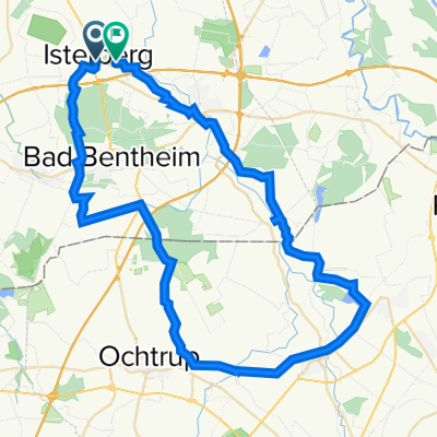
D - Bad Bentheim - GFT4 - 35 (45) km
A cycling route starting in Isterberg, Lower Saxony, Germany.
Overview
About this route
D - Bad Bentheim - GFT4 - 35 (45) km
- -:--
- Duration
- 32.7 km
- Distance
- 55 m
- Ascent
- 53 m
- Descent
- ---
- Avg. speed
- ---
- Max. altitude

Route quality
Waytypes & surfaces along the route
Waytypes
Quiet road
22.9 km
(70 %)
Track
4.6 km
(14 %)
Surfaces
Paved
21.9 km
(67 %)
Unpaved
2.9 km
(9 %)
Asphalt
13.8 km
(42 %)
Paved (undefined)
6.5 km
(20 %)
Continue with Bikemap
Use, edit, or download this cycling route
You would like to ride D - Bad Bentheim - GFT4 - 35 (45) km or customize it for your own trip? Here is what you can do with this Bikemap route:
Free features
- Save this route as favorite or in collections
- Copy & plan your own version of this route
- Sync your route with Garmin or Wahoo
Premium features
Free trial for 3 days, or one-time payment. More about Bikemap Premium.
- Navigate this route on iOS & Android
- Export a GPX / KML file of this route
- Create your custom printout (try it for free)
- Download this route for offline navigation
Discover more Premium features.
Get Bikemap PremiumFrom our community
Other popular routes starting in Isterberg
 Tagesroute 5
- Distance
- 48.1 km
- Ascent
- 41 m
- Descent
- 41 m
- Location
- Isterberg, Lower Saxony, Germany
 Laudiek 3, Isterberg nach Laudiek 8, Isterberg
- Distance
- 58.9 km
- Ascent
- 645 m
- Descent
- 568 m
- Location
- Isterberg, Lower Saxony, Germany
 GFT 4_Hochwasserstrecke
- Distance
- 32.7 km
- Ascent
- 55 m
- Descent
- 53 m
- Location
- Isterberg, Lower Saxony, Germany
 N&F 2. Engdener Wüste herum
- Distance
- 51.5 km
- Ascent
- 77 m
- Descent
- 80 m
- Location
- Isterberg, Lower Saxony, Germany
 GFT5
GFT5- Distance
- 47.2 km
- Ascent
- 57 m
- Descent
- 56 m
- Location
- Isterberg, Lower Saxony, Germany
 6. Grafschafter Anfietsen: Tour Bad Bentheim & Schüttorf -Wietmarschen
- Distance
- 27.6 km
- Ascent
- 26 m
- Descent
- 35 m
- Location
- Isterberg, Lower Saxony, Germany
 Meine Rentnertour
- Distance
- 50.6 km
- Ascent
- 45 m
- Descent
- 49 m
- Location
- Isterberg, Lower Saxony, Germany
 20_2023_Grensoverschrijdende_Theetuinen_Noord
- Distance
- 42.7 km
- Ascent
- 200 m
- Descent
- 199 m
- Location
- Isterberg, Lower Saxony, Germany
Open it in the app