

20150809_120746.gpx
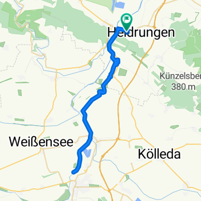
A cycling route starting in Heldrungen, Thuringia, Germany.
Overview
About this route
TEASI track
- -:--
- Duration
- 13.4 km
- Distance
- 54 m
- Ascent
- 52 m
- Descent
- ---
- Avg. speed
- ---
- Max. altitude
Continue with Bikemap
Use, edit, or download this cycling route
You would like to ride 20150809_120746.gpx or customize it for your own trip? Here is what you can do with this Bikemap route:
Free features
- Save this route as favorite or in collections
- Copy & plan your own version of this route
- Sync your route with Garmin or Wahoo
Premium features
Free trial for 3 days, or one-time payment. More about Bikemap Premium.
- Navigate this route on iOS & Android
- Export a GPX / KML file of this route
- Create your custom printout (try it for free)
- Download this route for offline navigation
Discover more Premium features.
Get Bikemap PremiumFrom our community
Other popular routes starting in Heldrungen
 Am Schwimmbad 73, Heldrungen nach Am Schwimmbad 73, Heldrungen
- Distance
- 42.2 km
- Ascent
- 105 m
- Descent
- 150 m
- Location
- Heldrungen, Thuringia, Germany
 Goethetour 2016 - 1.Etappe
- Distance
- 126.3 km
- Ascent
- 795 m
- Descent
- 795 m
- Location
- Heldrungen, Thuringia, Germany
 Heldrungen - Waldschlößchen
- Distance
- 40.4 km
- Ascent
- 105 m
- Descent
- 96 m
- Location
- Heldrungen, Thuringia, Germany
 Goethetour 2016 - 2.Etappe Nr.1
- Distance
- 119.3 km
- Ascent
- 287 m
- Descent
- 290 m
- Location
- Heldrungen, Thuringia, Germany
 Goethetour 2016 - 4. Etappe
- Distance
- 73.5 km
- Ascent
- 461 m
- Descent
- 462 m
- Location
- Heldrungen, Thuringia, Germany
 12.6.25 - Etappe 4
- Distance
- 28.8 km
- Ascent
- 104 m
- Descent
- 162 m
- Location
- Heldrungen, Thuringia, Germany
 Heldrungen-Erfurt
- Distance
- 48.5 km
- Ascent
- 138 m
- Descent
- 79 m
- Location
- Heldrungen, Thuringia, Germany
 Ichtershausen-Schönebeck 2. Tag nach Freyburg
- Distance
- 61.8 km
- Ascent
- 220 m
- Descent
- 237 m
- Location
- Heldrungen, Thuringia, Germany
Open it in the app