
GFNY ventoux 2017
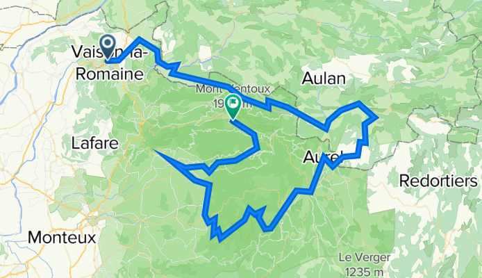
A cycling route starting in Vaison-la-Romaine, Provence-Alpes-Côte d'Azur Region, France.
Overview
About this route
si sale fino alla sommet du omp mort, ascesa tranquilla per poi scendere veloci fra i campi di lavanda; dopo un pezzo di trasferimento si percorre una gola tutta in quota (veramente un bel tratto) per poi scendere a Flassan. Via fino a Bedoin dove si gira e a breve inizia l'ascesa finale. Gli ultimi 20km circa servono a scalare il Ventoux: non è cattivo ma non molla mai fino in cima e gli ultimi 3 km presentano le pendenze peggiori.
- -:--
- Duration
- 132.8 km
- Distance
- 3,049 m
- Ascent
- 1,363 m
- Descent
- ---
- Avg. speed
- ---
- Max. altitude

Route quality
Waytypes & surfaces along the route
Waytypes
Road
62.4 km
(47 %)
Quiet road
2.7 km
(2 %)
Surfaces
Paved
87.6 km
(66 %)
Asphalt
87.6 km
(66 %)
Undefined
45.1 km
(34 %)
Continue with Bikemap
Use, edit, or download this cycling route
You would like to ride GFNY ventoux 2017 or customize it for your own trip? Here is what you can do with this Bikemap route:
Free features
- Save this route as favorite or in collections
- Copy & plan your own version of this route
- Split it into stages to create a multi-day tour
- Sync your route with Garmin or Wahoo
Premium features
Free trial for 3 days, or one-time payment. More about Bikemap Premium.
- Navigate this route on iOS & Android
- Export a GPX / KML file of this route
- Create your custom printout (try it for free)
- Download this route for offline navigation
Discover more Premium features.
Get Bikemap PremiumFrom our community
Other popular routes starting in Vaison-la-Romaine
 Provence: Dentelles de Momtmirail und Toulerenctal
- Distance
- 59.6 km
- Ascent
- 1,298 m
- Descent
- 1,287 m
- Location
- Vaison-la-Romaine, Provence-Alpes-Côte d'Azur Region, France
 Provence: Eyguestal
- Distance
- 56.1 km
- Ascent
- 608 m
- Descent
- 608 m
- Location
- Vaison-la-Romaine, Provence-Alpes-Côte d'Azur Region, France
 Vaison - Gigondas
- Distance
- 49.2 km
- Ascent
- 510 m
- Descent
- 508 m
- Location
- Vaison-la-Romaine, Provence-Alpes-Côte d'Azur Region, France
 Provence: Enklave der Päpste
- Distance
- 56.4 km
- Ascent
- 635 m
- Descent
- 635 m
- Location
- Vaison-la-Romaine, Provence-Alpes-Côte d'Azur Region, France
 Mont Ventoux 1
- Distance
- 125 km
- Ascent
- 2,015 m
- Descent
- 2,015 m
- Location
- Vaison-la-Romaine, Provence-Alpes-Côte d'Azur Region, France
 Provence: Col d`Ey
- Distance
- 79.8 km
- Ascent
- 1,490 m
- Descent
- 1,353 m
- Location
- Vaison-la-Romaine, Provence-Alpes-Côte d'Azur Region, France
 Provence: Klosterruine Prebayon
- Distance
- 29.5 km
- Ascent
- 510 m
- Descent
- 510 m
- Location
- Vaison-la-Romaine, Provence-Alpes-Côte d'Azur Region, France
 Vaison Rundtour
- Distance
- 16 km
- Ascent
- 245 m
- Descent
- 247 m
- Location
- Vaison-la-Romaine, Provence-Alpes-Côte d'Azur Region, France
Open it in the app