

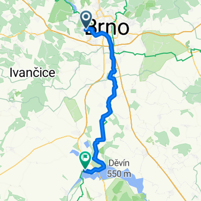
Overview
About this route
- -:--
- Duration
- 33.7 km
- Distance
- 339 m
- Ascent
- 339 m
- Descent
- ---
- Avg. speed
- ---
- Max. altitude

Part of
Moje švihání
6 stages
Route quality
Waytypes & surfaces along the route
Waytypes
Road
26.6 km
(79 %)
Track
2.4 km
(7 %)
Surfaces
Paved
25.6 km
(76 %)
Asphalt
24.9 km
(74 %)
Paved (undefined)
0.7 km
(2 %)
Undefined
8.1 km
(24 %)
Continue with Bikemap
Use, edit, or download this cycling route
You would like to ride Ořechov-Omice or customize it for your own trip? Here is what you can do with this Bikemap route:
Free features
- Save this route as favorite or in collections
- Copy & plan your own version of this route
- Sync your route with Garmin or Wahoo
Premium features
Free trial for 3 days, or one-time payment. More about Bikemap Premium.
- Navigate this route on iOS & Android
- Export a GPX / KML file of this route
- Create your custom printout (try it for free)
- Download this route for offline navigation
Discover more Premium features.
Get Bikemap PremiumFrom our community
Other popular routes starting in Ostopovice
 Novy Liskovec-Vystaviste-Botanicka
- Distance
- 7.4 km
- Ascent
- 88 m
- Descent
- 151 m
- Location
- Ostopovice, South Moravian, Czechia
 BRNO - Dam 2
- Distance
- 47.6 km
- Ascent
- 493 m
- Descent
- 492 m
- Location
- Ostopovice, South Moravian, Czechia
 Potocká to Pasohlávky
- Distance
- 50.7 km
- Ascent
- 219 m
- Descent
- 361 m
- Location
- Ostopovice, South Moravian, Czechia
 Nový Lískovec - Kohoutovice - obora Holedná - Jundrov - Bystrc, pěšky
- Distance
- 9.5 km
- Ascent
- 156 m
- Descent
- 248 m
- Location
- Ostopovice, South Moravian, Czechia
 Libušino údolí 200, Brno to Vomáčkova
- Distance
- 8.2 km
- Ascent
- 12 m
- Descent
- 121 m
- Location
- Ostopovice, South Moravian, Czechia
 Personal Route for Sunday
- Distance
- 14.8 km
- Ascent
- 305 m
- Descent
- 303 m
- Location
- Ostopovice, South Moravian, Czechia
 Brno - Macocha - Brno
- Distance
- 82.3 km
- Ascent
- 783 m
- Descent
- 764 m
- Location
- Ostopovice, South Moravian, Czechia
 znojemská
- Distance
- 189 km
- Ascent
- 826 m
- Descent
- 822 m
- Location
- Ostopovice, South Moravian, Czechia
Open it in the app