

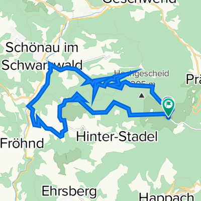
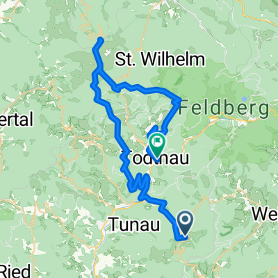
Wiesental Ostseite
A cycling route starting in Tunau, Baden-Wurttemberg, Germany.
Overview
About this route
Circular tour from Herrenschwand via - Tunau - Holz - Stadel - Ehrsberg and back.
Wonderful deep and panoramic views into the Wiesental and on the Belchen.
- -:--
- Duration
- 32 km
- Distance
- 951 m
- Ascent
- 952 m
- Descent
- ---
- Avg. speed
- ---
- Max. altitude
Route quality
Waytypes & surfaces along the route
Waytypes
Track
20.2 km
(63 %)
Quiet road
7.7 km
(24 %)
Surfaces
Paved
4.5 km
(14 %)
Unpaved
19.5 km
(61 %)
Unpaved (undefined)
10.9 km
(34 %)
Gravel
8.3 km
(26 %)
Continue with Bikemap
Use, edit, or download this cycling route
You would like to ride Wiesental Ostseite or customize it for your own trip? Here is what you can do with this Bikemap route:
Free features
- Save this route as favorite or in collections
- Copy & plan your own version of this route
- Sync your route with Garmin or Wahoo
Premium features
Free trial for 3 days, or one-time payment. More about Bikemap Premium.
- Navigate this route on iOS & Android
- Export a GPX / KML file of this route
- Create your custom printout (try it for free)
- Download this route for offline navigation
Discover more Premium features.
Get Bikemap PremiumFrom our community
Other popular routes starting in Tunau
 Riedisheim - Colombier-Fontaine
- Distance
- 151.4 km
- Ascent
- 1,090 m
- Descent
- 1,528 m
- Location
- Tunau, Baden-Wurttemberg, Germany
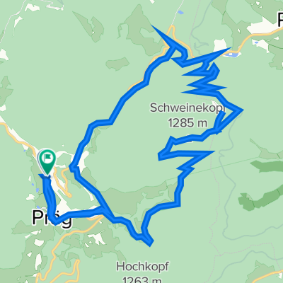
 Prägwanderung
- Distance
- 14.3 km
- Ascent
- 622 m
- Descent
- 621 m
- Location
- Tunau, Baden-Wurttemberg, Germany
 Hochkopfstraße 1, Todtnau nach Todtnauerliweg, Utzenfeld
- Distance
- 17.9 km
- Ascent
- 1,587 m
- Descent
- 1,685 m
- Location
- Tunau, Baden-Wurttemberg, Germany
 Dorfstraße 11, Tunau nach Ziegelweg 28, Freiburg im Breisgau
- Distance
- 33.8 km
- Ascent
- 646 m
- Descent
- 1,099 m
- Location
- Tunau, Baden-Wurttemberg, Germany
 23SW-Tunau20-600
- Distance
- 19.9 km
- Ascent
- 735 m
- Descent
- 737 m
- Location
- Tunau, Baden-Wurttemberg, Germany
 Präg-Knöpflesbrunnnen-Todtnau
- Distance
- 43.2 km
- Ascent
- 954 m
- Descent
- 1,021 m
- Location
- Tunau, Baden-Wurttemberg, Germany
 präg Blößling Präg
- Distance
- 17.8 km
- Ascent
- 658 m
- Descent
- 656 m
- Location
- Tunau, Baden-Wurttemberg, Germany
 Hotzenwald
- Distance
- 99.5 km
- Ascent
- 2,719 m
- Descent
- 2,723 m
- Location
- Tunau, Baden-Wurttemberg, Germany
Open it in the app