

lavagna-gattorna-casella-genova (corretto)
A cycling route starting in Lavagna, Liguria, Italy.
Overview
About this route
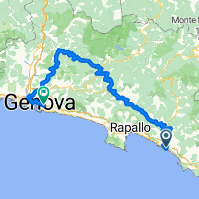
Scenic route that initially follows the Entella river cycle and pedestrian path, and then continues on the Brenner cycle route up to Casella.
From Casella, the route descends towards Genoa, also riding various unpaved trails, such as the aqueduct trail, the butterfly trail, and the Mura trail.
- -:--
- Duration
- 97 km
- Distance
- 1,093 m
- Ascent
- 1,088 m
- Descent
- ---
- Avg. speed
- ---
- Max. altitude
Route quality
Waytypes & surfaces along the route
Waytypes
Quiet road
22.3 km
(23 %)
Cycleway
10.7 km
(11 %)
Surfaces
Paved
45.6 km
(47 %)
Unpaved
15.5 km
(16 %)
Asphalt
45.6 km
(47 %)
Unpaved (undefined)
8.7 km
(9 %)
Continue with Bikemap
Use, edit, or download this cycling route
You would like to ride lavagna-gattorna-casella-genova (corretto) or customize it for your own trip? Here is what you can do with this Bikemap route:
Free features
- Save this route as favorite or in collections
- Copy & plan your own version of this route
- Split it into stages to create a multi-day tour
- Sync your route with Garmin or Wahoo
Premium features
Free trial for 3 days, or one-time payment. More about Bikemap Premium.
- Navigate this route on iOS & Android
- Export a GPX / KML file of this route
- Create your custom printout (try it for free)
- Download this route for offline navigation
Discover more Premium features.
Get Bikemap PremiumFrom our community
Other popular routes starting in Lavagna
 Recovered Route
- Distance
- 52.1 km
- Ascent
- 0 m
- Descent
- 4 m
- Location
- Lavagna, Liguria, Italy
 Lungo Entella 25–47, Lavagna a Via dei Devoto 182, Lavagna
- Distance
- 30.1 km
- Ascent
- 352 m
- Descent
- 348 m
- Location
- Lavagna, Liguria, Italy
 Lavagna-Casarza Ligure-anello Riva Trigoso-Lavagna
- Distance
- 37.6 km
- Ascent
- 819 m
- Descent
- 815 m
- Location
- Lavagna, Liguria, Italy
 Chiavari-Conscenti
- Distance
- 32.3 km
- Ascent
- 445 m
- Descent
- 447 m
- Location
- Lavagna, Liguria, Italy
 Lavagna - Passo del Biscia - Varese L - Levanto
- Distance
- 86.2 km
- Ascent
- 1,370 m
- Descent
- 1,342 m
- Location
- Lavagna, Liguria, Italy
 Lavagna-Gattorna-Casella-Genova
- Distance
- 99.3 km
- Ascent
- 1,324 m
- Descent
- 1,319 m
- Location
- Lavagna, Liguria, Italy
 Lavagna -Val Fontanabuona - Val Borbera -San Sebastiano
- Distance
- 104.2 km
- Ascent
- 1,916 m
- Descent
- 1,581 m
- Location
- Lavagna, Liguria, Italy
 al mare...
- Distance
- 18 km
- Ascent
- 0 m
- Descent
- 4 m
- Location
- Lavagna, Liguria, Italy
Open it in the app