
France 2017 - Tour De Force
France 2017 - Stage Two
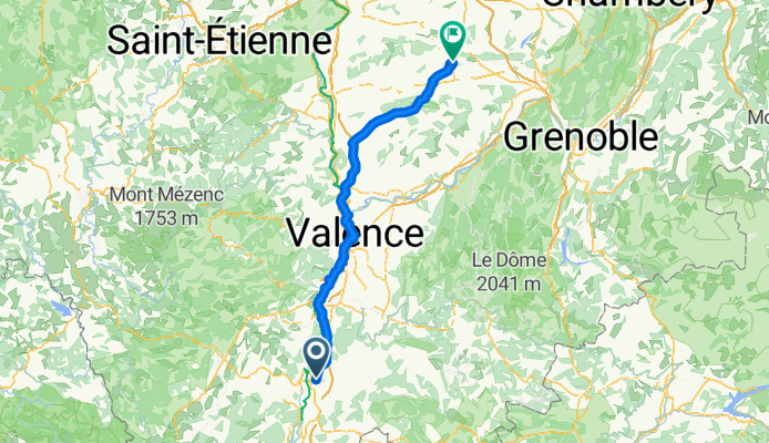
A cycling route starting in Montélimar, Auvergne-Rhône-Alpes, France.
Overview
About this route
Montelimar to La Cote Saint Andre (Valence as the Stop)
- -:--
- Duration
- 131.3 km
- Distance
- 578 m
- Ascent
- 291 m
- Descent
- ---
- Avg. speed
- ---
- Max. altitude

Part of

France 2017 - Tour De Force
4 stages
Route quality
Waytypes & surfaces along the route
Waytypes
Quiet road
35.4 km
(27 %)
Road
31.5 km
(24 %)
Surfaces
Paved
53.8 km
(41 %)
Unpaved
7.9 km
(6 %)
Asphalt
48.6 km
(37 %)
Paved (undefined)
5.3 km
(4 %)
Continue with Bikemap
Use, edit, or download this cycling route
You would like to ride France 2017 - Stage Two or customize it for your own trip? Here is what you can do with this Bikemap route:
Free features
- Save this route as favorite or in collections
- Copy & plan your own version of this route
- Split it into stages to create a multi-day tour
- Sync your route with Garmin or Wahoo
Premium features
Free trial for 3 days, or one-time payment. More about Bikemap Premium.
- Navigate this route on iOS & Android
- Export a GPX / KML file of this route
- Create your custom printout (try it for free)
- Download this route for offline navigation
Discover more Premium features.
Get Bikemap PremiumFrom our community
Other popular routes starting in Montélimar
 pour aller chez Hervé
- Distance
- 62.3 km
- Ascent
- 520 m
- Descent
- 475 m
- Location
- Montélimar, Auvergne-Rhône-Alpes, France
 C'est beau le Niger (provençal) à vélo 2016
- Distance
- 365.8 km
- Ascent
- 2,835 m
- Descent
- 2,886 m
- Location
- Montélimar, Auvergne-Rhône-Alpes, France
 Aleyrac
- Distance
- 63.2 km
- Ascent
- 791 m
- Descent
- 791 m
- Location
- Montélimar, Auvergne-Rhône-Alpes, France
 2016 Ride Day 97 - Montélimar Circle to East
- Distance
- 64.8 km
- Ascent
- 548 m
- Descent
- 548 m
- Location
- Montélimar, Auvergne-Rhône-Alpes, France
 Montélimar to Fournès
- Distance
- 87.4 km
- Ascent
- 654 m
- Descent
- 674 m
- Location
- Montélimar, Auvergne-Rhône-Alpes, France
 6- Montélimar - Roquemaure
- Distance
- 76.6 km
- Ascent
- 12 m
- Descent
- 64 m
- Location
- Montélimar, Auvergne-Rhône-Alpes, France
 Etape 4 : Montelimar ==> Pont ST Esprit
- Distance
- 47.9 km
- Ascent
- 50 m
- Descent
- 76 m
- Location
- Montélimar, Auvergne-Rhône-Alpes, France
 13. Tag Saint Julien du Gua - Saint Nazaire en Royans
- Distance
- 103.8 km
- Ascent
- 219 m
- Descent
- 132 m
- Location
- Montélimar, Auvergne-Rhône-Alpes, France
Open it in the app