

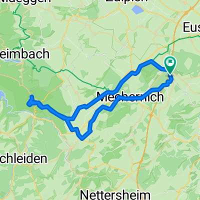
Mechernich-Euskirchen-Schleidtal-Euskirchen-Mechernich
A cycling route starting in Mechernich, North Rhine-Westphalia, Germany.
Overview
About this route
Relativ Flache Runde mit dem Highlight Schleidtal
- -:--
- Duration
- 75.1 km
- Distance
- 501 m
- Ascent
- 621 m
- Descent
- ---
- Avg. speed
- 461 m
- Max. altitude
Route quality
Waytypes & surfaces along the route
Waytypes
Quiet road
23.4 km
(31 %)
Busy road
18.6 km
(25 %)
Surfaces
Paved
63.4 km
(84 %)
Unpaved
3.5 km
(5 %)
Asphalt
59.3 km
(79 %)
Paved (undefined)
2.2 km
(3 %)
Continue with Bikemap
Use, edit, or download this cycling route
You would like to ride Mechernich-Euskirchen-Schleidtal-Euskirchen-Mechernich or customize it for your own trip? Here is what you can do with this Bikemap route:
Free features
- Save this route as favorite or in collections
- Copy & plan your own version of this route
- Sync your route with Garmin or Wahoo
Premium features
Free trial for 3 days, or one-time payment. More about Bikemap Premium.
- Navigate this route on iOS & Android
- Export a GPX / KML file of this route
- Create your custom printout (try it for free)
- Download this route for offline navigation
Discover more Premium features.
Get Bikemap PremiumFrom our community
Other popular routes starting in Mechernich
 Lessenich - Eschweilerbachtal- Lessenich
- Distance
- 24.5 km
- Ascent
- 244 m
- Descent
- 244 m
- Location
- Mechernich, North Rhine-Westphalia, Germany
 Mechernich- Bad Münstereifel- Wasserscheide- Pesch- Mechernich
- Distance
- 55.6 km
- Ascent
- 722 m
- Descent
- 613 m
- Location
- Mechernich, North Rhine-Westphalia, Germany
 Lessenich - Wolfgarten (Kermeter) und zurück
- Distance
- 46.4 km
- Ascent
- 457 m
- Descent
- 454 m
- Location
- Mechernich, North Rhine-Westphalia, Germany
 Schmidtheimer Runde
- Distance
- 80.5 km
- Ascent
- 1,023 m
- Descent
- 1,031 m
- Location
- Mechernich, North Rhine-Westphalia, Germany
 Runde über Schleiden
- Distance
- 43.6 km
- Ascent
- 585 m
- Descent
- 574 m
- Location
- Mechernich, North Rhine-Westphalia, Germany
 EifelSchleife Burg Satzvey (Stadt Mechernich) - EifelSchleife Burg Satzvey (Stadt Mechernich)
- Distance
- 7.3 km
- Ascent
- 105 m
- Descent
- 109 m
- Location
- Mechernich, North Rhine-Westphalia, Germany
 Querlenker Tour (35,09km, Start Firmenich)
- Distance
- 35.1 km
- Ascent
- 506 m
- Descent
- 508 m
- Location
- Mechernich, North Rhine-Westphalia, Germany
 Eifelhöhen 2020
- Distance
- 46.9 km
- Ascent
- 637 m
- Descent
- 632 m
- Location
- Mechernich, North Rhine-Westphalia, Germany
Open it in the app