Brünlastour
A cycling route starting in Scheibenberg, Saxony, Germany.
Overview
About this route
Kurze Tour Richtung Elterlein Auf ca. halber Strecke Gaststätte Jägersruh
- -:--
- Duration
- 8 km
- Distance
- 115 m
- Ascent
- 116 m
- Descent
- ---
- Avg. speed
- ---
- Max. altitude
Route quality
Waytypes & surfaces along the route
Waytypes
Track
3.8 km
(47 %)
Quiet road
1.9 km
(24 %)
Surfaces
Paved
5 km
(62 %)
Unpaved
2.3 km
(29 %)
Asphalt
4.3 km
(54 %)
Loose gravel
1.5 km
(19 %)
Continue with Bikemap
Use, edit, or download this cycling route
You would like to ride Brünlastour or customize it for your own trip? Here is what you can do with this Bikemap route:
Free features
- Save this route as favorite or in collections
- Copy & plan your own version of this route
- Sync your route with Garmin or Wahoo
Premium features
Free trial for 3 days, or one-time payment. More about Bikemap Premium.
- Navigate this route on iOS & Android
- Export a GPX / KML file of this route
- Create your custom printout (try it for free)
- Download this route for offline navigation
Discover more Premium features.
Get Bikemap PremiumFrom our community
Other popular routes starting in Scheibenberg
- Brünlastour
- Distance
- 8 km
- Ascent
- 115 m
- Descent
- 116 m
- Location
- Scheibenberg, Saxony, Germany
- Pfingstrunde
- Distance
- 74.7 km
- Ascent
- 700 m
- Descent
- 700 m
- Location
- Scheibenberg, Saxony, Germany
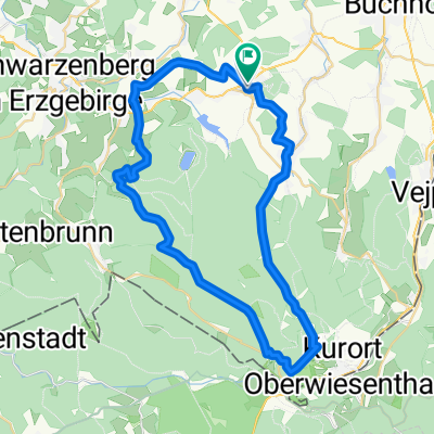
- Fichtelberg und zurück
- Distance
- 37.1 km
- Ascent
- 841 m
- Descent
- 865 m
- Location
- Scheibenberg, Saxony, Germany
- Karzl-Tour von Neudorf nach Scheibenberg und zurück
- Distance
- 48.8 km
- Ascent
- 1,210 m
- Descent
- 1,211 m
- Location
- Scheibenberg, Saxony, Germany
- 04 Scheibenberg-Rabenberg
- Distance
- 37.7 km
- Ascent
- 934 m
- Descent
- 879 m
- Location
- Scheibenberg, Saxony, Germany
- Radtour Rund um Scheibenberg
- Distance
- 6.3 km
- Ascent
- 91 m
- Descent
- 98 m
- Location
- Scheibenberg, Saxony, Germany
- Scheibenberg-Fichtelberg-Scheibenberg
- Distance
- 45.9 km
- Ascent
- 1,071 m
- Descent
- 1,091 m
- Location
- Scheibenberg, Saxony, Germany
- Zum Geyrischen Teich über den Mittelpunkt des Erzgebirgskreis
- Distance
- 35.3 km
- Ascent
- 593 m
- Descent
- 594 m
- Location
- Scheibenberg, Saxony, Germany
Open it in the app