

My Tour
A cycling route starting in Rathmannsdorf, Saxony, Germany.
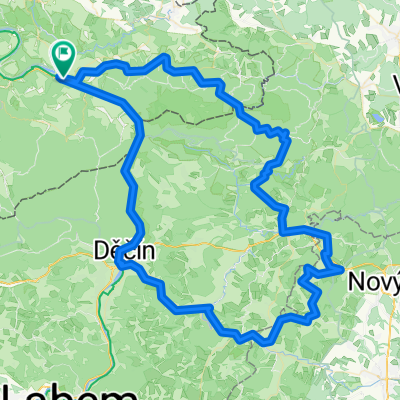
Overview
About this route
Bad Schandau - Radebeul. NizzaStr. 55
- -:--
- Duration
- 55.9 km
- Distance
- 135 m
- Ascent
- 134 m
- Descent
- ---
- Avg. speed
- ---
- Max. altitude
Route quality
Waytypes & surfaces along the route
Waytypes
Quiet road
14 km
(25 %)
Cycleway
14 km
(25 %)
Surfaces
Paved
45.8 km
(82 %)
Unpaved
7.3 km
(13 %)
Asphalt
45.8 km
(82 %)
Ground
6.7 km
(12 %)
Continue with Bikemap
Use, edit, or download this cycling route
You would like to ride My Tour or customize it for your own trip? Here is what you can do with this Bikemap route:
Free features
- Save this route as favorite or in collections
- Copy & plan your own version of this route
- Sync your route with Garmin or Wahoo
Premium features
Free trial for 3 days, or one-time payment. More about Bikemap Premium.
- Navigate this route on iOS & Android
- Export a GPX / KML file of this route
- Create your custom printout (try it for free)
- Download this route for offline navigation
Discover more Premium features.
Get Bikemap PremiumFrom our community
Other popular routes starting in Rathmannsdorf
 schöne Trail-Runde über Bastei-Wehlen-Lilienstein
- Distance
- 49.5 km
- Ascent
- 633 m
- Descent
- 633 m
- Location
- Rathmannsdorf, Saxony, Germany
 F100N423Elberadweg Tag 1 und Tag 2 und weitere
- Distance
- 423.4 km
- Ascent
- 165 m
- Descent
- 223 m
- Location
- Rathmannsdorf, Saxony, Germany
 Rund um die Böhmische Schweiz
- Distance
- 71.3 km
- Ascent
- 1,248 m
- Descent
- 1,166 m
- Location
- Rathmannsdorf, Saxony, Germany
 Bad Schandau - DD - Bad Schandau
- Distance
- 46.9 km
- Ascent
- 369 m
- Descent
- 384 m
- Location
- Rathmannsdorf, Saxony, Germany
 Bergmannstraße nach Schmilka
- Distance
- 8.9 km
- Ascent
- 45 m
- Descent
- 60 m
- Location
- Rathmannsdorf, Saxony, Germany
 RUD06_08_Bad Schandau – Zalhostice / Lukavec / Prosmyky
- Distance
- 69.1 km
- Ascent
- 448 m
- Descent
- 423 m
- Location
- Rathmannsdorf, Saxony, Germany
 Gravelrunde durch die Sächsische und Böhmische Schweiz
- Distance
- 113 km
- Ascent
- 1,101 m
- Descent
- 1,108 m
- Location
- Rathmannsdorf, Saxony, Germany
 Grenzfahrt(en)
- Distance
- 48.3 km
- Ascent
- 966 m
- Descent
- 959 m
- Location
- Rathmannsdorf, Saxony, Germany
Open it in the app