

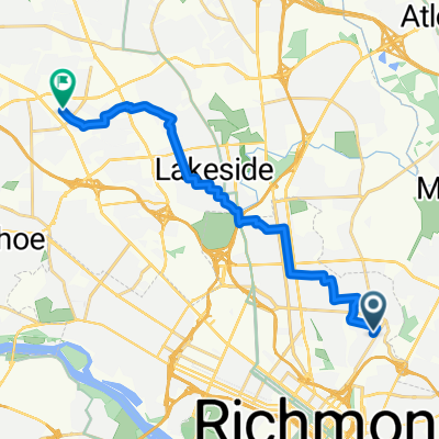
Public Safety Community Bike Ride
A cycling route starting in East Highland Park, Virginia, United States.
Overview
About this route
This is an annual community bike ride with the communiyt and public safety.
- -:--
- Duration
- 18.5 km
- Distance
- 90 m
- Ascent
- 113 m
- Descent
- ---
- Avg. speed
- ---
- Max. altitude

Route quality
Waytypes & surfaces along the route
Waytypes
Quiet road
10.7 km
(58 %)
Road
4.8 km
(26 %)
Surfaces
Paved
0.9 km
(5 %)
Asphalt
0.9 km
(5 %)
Undefined
17.6 km
(95 %)
Route highlights
Points of interest along the route
Point of interest after 0.4 km
2300 Cool Lane Start /Finish
Point of interest after 1.4 km
Post #2
Point of interest after 1.8 km
Post #3
Point of interest after 2.6 km
Post #5
Point of interest after 3.8 km
Post #7
Point of interest after 3.9 km
Point of interest after 4.2 km
Post #6
Point of interest after 7.1 km
Post #1
Point of interest after 8.1 km
Post #9
Point of interest after 9 km
Post #10
Point of interest after 9 km
Post #11
Point of interest after 9.3 km
Post #12
Point of interest after 9.3 km
Post #13
Point of interest after 9.6 km
post #14
Point of interest after 9.8 km
Post #15
Point of interest after 10 km
Post #16
Point of interest after 10.3 km
Post #17
Point of interest after 10.6 km
Post #20
Point of interest after 11.6 km
Post #21
Point of interest after 12.1 km
Post #22
Point of interest after 12.2 km
Post #23
Point of interest after 12.2 km
Post #24
Point of interest after 12.3 km
Post #25
Point of interest after 14.7 km
Post #22
Point of interest after 16.2 km
Post #26
Point of interest after 18.2 km
Post #4
Continue with Bikemap
Use, edit, or download this cycling route
You would like to ride Public Safety Community Bike Ride or customize it for your own trip? Here is what you can do with this Bikemap route:
Free features
- Save this route as favorite or in collections
- Copy & plan your own version of this route
- Sync your route with Garmin or Wahoo
Premium features
Free trial for 3 days, or one-time payment. More about Bikemap Premium.
- Navigate this route on iOS & Android
- Export a GPX / KML file of this route
- Create your custom printout (try it for free)
- Download this route for offline navigation
Discover more Premium features.
Get Bikemap PremiumFrom our community
Other popular routes starting in East Highland Park
 Public Safety Bike Ride 2017
- Distance
- 7.5 km
- Ascent
- 48 m
- Descent
- 50 m
- Location
- East Highland Park, Virginia, United States
 3127 Garland Ave, Richmond to 3201 Garland Ave, Richmond
- Distance
- 6.4 km
- Ascent
- 50 m
- Descent
- 54 m
- Location
- East Highland Park, Virginia, United States
 3201 Garland Ave, Richmond to 3202 Garland Ave, Richmond
- Distance
- 6.5 km
- Ascent
- 42 m
- Descent
- 16 m
- Location
- East Highland Park, Virginia, United States
 Fourth Ave, Richmond to W Broad St, Henrico
- Distance
- 16.6 km
- Ascent
- 100 m
- Descent
- 58 m
- Location
- East Highland Park, Virginia, United States
 Fourth Ave, Richmond to Oliver Hill Way, Richmond
- Distance
- 2.4 km
- Ascent
- 3 m
- Descent
- 26 m
- Location
- East Highland Park, Virginia, United States
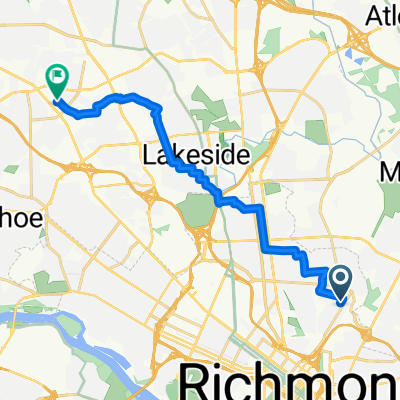
 Public Safety Community Bike Ride
- Distance
- 18.5 km
- Ascent
- 90 m
- Descent
- 113 m
- Location
- East Highland Park, Virginia, United States
 MTN Cat 2021
- Distance
- 187 km
- Ascent
- 3,875 m
- Descent
- 3,869 m
- Location
- East Highland Park, Virginia, United States
 Fourth Ave, Richmond to W Broad St, Henrico
- Distance
- 16.7 km
- Ascent
- 89 m
- Descent
- 52 m
- Location
- East Highland Park, Virginia, United States
Open it in the app