

Parijs - Apeldoorn 2e etappe nieuwee route
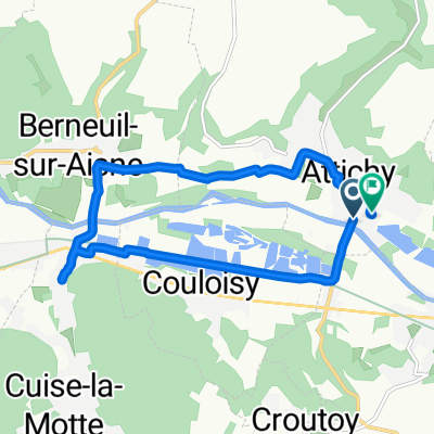
A cycling route starting in Attichy, Hauts-de-France, France.
Overview
About this route
- -:--
- Duration
- 83.5 km
- Distance
- 394 m
- Ascent
- 356 m
- Descent
- ---
- Avg. speed
- ---
- Max. altitude

Route quality
Waytypes & surfaces along the route
Waytypes
Road
55.5 km
(66 %)
Quiet road
16.1 km
(19 %)
Surfaces
Paved
27.2 km
(33 %)
Asphalt
27.2 km
(33 %)
Undefined
56.2 km
(67 %)
Continue with Bikemap
Use, edit, or download this cycling route
You would like to ride Parijs - Apeldoorn 2e etappe nieuwee route or customize it for your own trip? Here is what you can do with this Bikemap route:
Free features
- Save this route as favorite or in collections
- Copy & plan your own version of this route
- Split it into stages to create a multi-day tour
- Sync your route with Garmin or Wahoo
Premium features
Free trial for 3 days, or one-time payment. More about Bikemap Premium.
- Navigate this route on iOS & Android
- Export a GPX / KML file of this route
- Create your custom printout (try it for free)
- Download this route for offline navigation
Discover more Premium features.
Get Bikemap PremiumFrom our community
Other popular routes starting in Attichy
 Tour 2014 Compiègne (Attichy) - Paris
- Distance
- 106.1 km
- Ascent
- 345 m
- Descent
- 351 m
- Location
- Attichy, Hauts-de-France, France
 Frb- Paris 2022 12. etape
- Distance
- 103.4 km
- Ascent
- 685 m
- Descent
- 663 m
- Location
- Attichy, Hauts-de-France, France
 Boucle du Triathlon d'Attichy 2011
- Distance
- 12.5 km
- Ascent
- 123 m
- Descent
- 123 m
- Location
- Attichy, Hauts-de-France, France
 Rue du 8 Mai 1945 13, Jaulzy to Pierrefonds
- Distance
- 11.4 km
- Ascent
- 195 m
- Descent
- 185 m
- Location
- Attichy, Hauts-de-France, France
 Rue de la Fontaine Aubier, Attichy à Rue de la Fontaine Aubier, Attichy
- Distance
- 10.3 km
- Ascent
- 99 m
- Descent
- 100 m
- Location
- Attichy, Hauts-de-France, France
 2diena iki kempingo paryziuje
- Distance
- 101.5 km
- Ascent
- 361 m
- Descent
- 361 m
- Location
- Attichy, Hauts-de-France, France
 Etappe 9
- Distance
- 73.3 km
- Ascent
- 401 m
- Descent
- 378 m
- Location
- Attichy, Hauts-de-France, France
 aigrette_Vimoutier
- Distance
- 296.6 km
- Ascent
- 651 m
- Descent
- 590 m
- Location
- Attichy, Hauts-de-France, France
Open it in the app