

2017
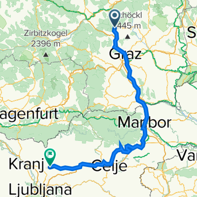
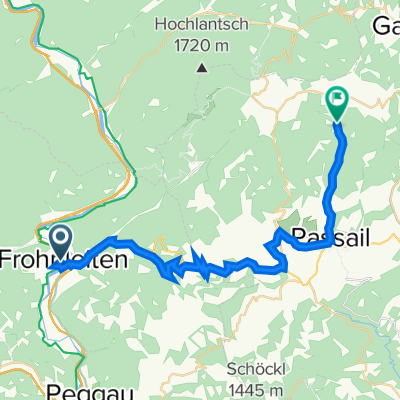
Frohnleiten (Römerpark) - Graz (Keplerbrücke)
A cycling route starting in Frohnleiten, Styria, Austria.
Overview
About this route
Routenverlauf:
Start = Frohnleiten Römerpark (20:18) - über Burg Rabenstein nach Deutschfeistritz (20:37) - durch Stübing (20:42) - links nach Friesach - links weg nach Gratkorn (über Eggenfeld) - Gratkorn Kreisverkehr Nord (20:52) - Andritz Arlandgrund (21:08) - rechts zum R2 - Keplerbrücke (21:14)= Ziel
Fahrzeit: 56 : 00 Minuten
Durchschn. Geschwindigkeit: 33,32 Km/H
Infos zum Rad:
SIMPLON PRIDE (8,77 kg) Carbon Rennrad mit Ksyrium Equippe Alu Laufradsatz / Rh: 54cm
Infos zu mir:
Mein aktuelles Gewicht: 64 kg / Körperfett: 5,0 %
Gewicht Ausrüstung + Zubehör (Tasche, Schlauch, Schuhe, Helm, ect.) : 1,9 kg
Was habt ihr für Zeiten für die Strecke und welchen Average Speed?
- -:--
- Duration
- 31.1 km
- Distance
- 125 m
- Ascent
- 200 m
- Descent
- ---
- Avg. speed
- ---
- Max. altitude

Part of
2017
1 stage
Route quality
Waytypes & surfaces along the route
Waytypes
Quiet road
12.8 km
(41 %)
Cycleway
9 km
(29 %)
Surfaces
Paved
28.3 km
(91 %)
Unpaved
1.9 km
(6 %)
Asphalt
28.3 km
(91 %)
Ground
1.6 km
(5 %)
Continue with Bikemap
Use, edit, or download this cycling route
You would like to ride Frohnleiten (Römerpark) - Graz (Keplerbrücke) or customize it for your own trip? Here is what you can do with this Bikemap route:
Free features
- Save this route as favorite or in collections
- Copy & plan your own version of this route
- Sync your route with Garmin or Wahoo
Premium features
Free trial for 3 days, or one-time payment. More about Bikemap Premium.
- Navigate this route on iOS & Android
- Export a GPX / KML file of this route
- Create your custom printout (try it for free)
- Download this route for offline navigation
Discover more Premium features.
Get Bikemap PremiumFrom our community
Other popular routes starting in Frohnleiten
 Route nach Kamnik
- Distance
- 246.5 km
- Ascent
- 2,037 m
- Descent
- 2,077 m
- Location
- Frohnleiten, Styria, Austria
 Frohnleiten - Passail
- Distance
- 55.7 km
- Ascent
- 1,623 m
- Descent
- 1,622 m
- Location
- Frohnleiten, Styria, Austria
 Frohnleiten Maribor Kamnik_V2
- Distance
- 226.6 km
- Ascent
- 1,905 m
- Descent
- 1,947 m
- Location
- Frohnleiten, Styria, Austria
 Drachentour
- Distance
- 64.4 km
- Ascent
- 2,126 m
- Descent
- 2,113 m
- Location
- Frohnleiten, Styria, Austria
 Frohleiten kratke kolecko
- Distance
- 33.7 km
- Ascent
- 1,006 m
- Descent
- 1,005 m
- Location
- Frohnleiten, Styria, Austria
 frohnleiten-passail-raabqu30km
- Distance
- 29.8 km
- Ascent
- 898 m
- Descent
- 433 m
- Location
- Frohnleiten, Styria, Austria
 Frohnleiten-Freisach-Frohnleiten
- Distance
- 33.1 km
- Ascent
- 151 m
- Descent
- 154 m
- Location
- Frohnleiten, Styria, Austria
 Frohnleiten Bruck an der Mur Hochganger Runde
- Distance
- 82.2 km
- Ascent
- 2,351 m
- Descent
- 2,338 m
- Location
- Frohnleiten, Styria, Austria
Open it in the app