
La Motte
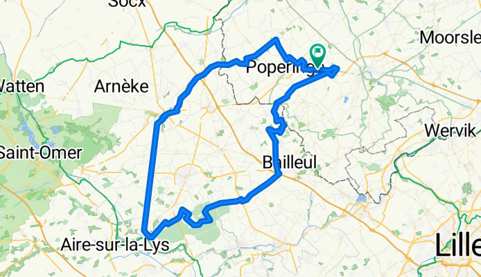
A cycling route starting in Poperinge, Flemish Region, Belgium.
Overview
About this route
There is actually nothing to see, but La Motte-au-Bois - a village in the middle of a forest - just sounds fun.
Between Cassel and Thiennes, you can seriously puff on a 14 km long straight section with a southerly wind.
There are some climbs, but you don't ride all the way up Kasselberg. The black mountain also only gets partly finished.
- -:--
- Duration
- 102 km
- Distance
- 261 m
- Ascent
- 261 m
- Descent
- ---
- Avg. speed
- ---
- Max. altitude

Route photos

Route quality
Waytypes & surfaces along the route
Waytypes
Road
46.9 km
(46 %)
Quiet road
46.9 km
(46 %)
Undefined
8.2 km
(8 %)
Surfaces
Paved
63.2 km
(62 %)
Asphalt
62.2 km
(61 %)
Concrete
1 km
(1 %)
Undefined
38.7 km
(38 %)
Continue with Bikemap
Use, edit, or download this cycling route
You would like to ride La Motte or customize it for your own trip? Here is what you can do with this Bikemap route:
Free features
- Save this route as favorite or in collections
- Copy & plan your own version of this route
- Split it into stages to create a multi-day tour
- Sync your route with Garmin or Wahoo
Premium features
Free trial for 3 days, or one-time payment. More about Bikemap Premium.
- Navigate this route on iOS & Android
- Export a GPX / KML file of this route
- Create your custom printout (try it for free)
- Download this route for offline navigation
Discover more Premium features.
Get Bikemap PremiumFrom our community
Other popular routes starting in Poperinge
 roesbrugge - de vierpot - 52
- Distance
- 52 km
- Ascent
- 193 m
- Descent
- 191 m
- Location
- Poperinge, Flemish Region, Belgium
 CL-GW2010 CLONED FROM ROUTE 485093
- Distance
- 82 km
- Ascent
- 651 m
- Descent
- 655 m
- Location
- Poperinge, Flemish Region, Belgium
 La Motte
- Distance
- 102 km
- Ascent
- 261 m
- Descent
- 261 m
- Location
- Poperinge, Flemish Region, Belgium
 2024-07-28 Watou - Ieper
- Distance
- 23.2 km
- Ascent
- 87 m
- Descent
- 83 m
- Location
- Poperinge, Flemish Region, Belgium
 hof van commerce - 41.3
- Distance
- 41.3 km
- Ascent
- 70 m
- Descent
- 68 m
- Location
- Poperinge, Flemish Region, Belgium
 Ronde van Westvleteren-Kemmel-Cassel
- Distance
- 103.8 km
- Ascent
- 550 m
- Descent
- 550 m
- Location
- Poperinge, Flemish Region, Belgium
 CL-GW2010
- Distance
- 86.2 km
- Ascent
- 863 m
- Descent
- 863 m
- Location
- Poperinge, Flemish Region, Belgium
 Deule - Heuvelland
- Distance
- 67.8 km
- Ascent
- 166 m
- Descent
- 168 m
- Location
- Poperinge, Flemish Region, Belgium
Open it in the app