

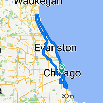
West Side
A cycling route starting in Chicago, Illinois, United States.
Overview
About this route
- -:--
- Duration
- 10.5 km
- Distance
- 8 m
- Ascent
- 8 m
- Descent
- ---
- Avg. speed
- ---
- Max. altitude

Route quality
Waytypes & surfaces along the route
Waytypes
Quiet road
4.8 km
(46 %)
Cycleway
4.2 km
(40 %)
Surfaces
Paved
9.1 km
(87 %)
Asphalt
4.6 km
(44 %)
Paved (undefined)
4.3 km
(41 %)
Route highlights
Points of interest along the route

Point of interest after 1.7 km
New Aldi and luxury condo building, currently under construction.

Point of interest after 1.8 km
The 606 in 2013, just before it was converted into a public-access trail. (Photo courtesy of SAIC)

Point of interest after 4.9 km
Abandoned warehouse at the western end of the 606 trail. When will it be renovated into expensive condos?

Point of interest after 5.8 km
An old building being gutted at the corner of St. Louis and Cortland.

Point of interest after 7.8 km
New luxury housing in Bucktown

Point of interest after 9.1 km
Infamously known as "The Crotch," this five-way intersection is unsafe for pedestrians, bikers, and cars alike.
Continue with Bikemap
Use, edit, or download this cycling route
You would like to ride West Side or customize it for your own trip? Here is what you can do with this Bikemap route:
Free features
- Save this route as favorite or in collections
- Copy & plan your own version of this route
- Sync your route with Garmin or Wahoo
Premium features
Free trial for 3 days, or one-time payment. More about Bikemap Premium.
- Navigate this route on iOS & Android
- Export a GPX / KML file of this route
- Create your custom printout (try it for free)
- Download this route for offline navigation
Discover more Premium features.
Get Bikemap PremiumFrom our community
Other popular routes starting in Chicago
 Chicago Century_2025
- Distance
- 160.4 km
- Ascent
- 535 m
- Descent
- 533 m
- Location
- Chicago, Illinois, United States
 Chicago - Milwaukee Retour
- Distance
- 414.3 km
- Ascent
- 324 m
- Descent
- 330 m
- Location
- Chicago, Illinois, United States
 Bike Trails
- Distance
- 188.4 km
- Ascent
- 629 m
- Descent
- 590 m
- Location
- Chicago, Illinois, United States
 South Bend Airport
- Distance
- 166.6 km
- Ascent
- 554 m
- Descent
- 517 m
- Location
- Chicago, Illinois, United States
 Chicago to Oak Lawn
- Distance
- 32 km
- Ascent
- 163 m
- Descent
- 154 m
- Location
- Chicago, Illinois, United States
 West Side
- Distance
- 10.5 km
- Ascent
- 8 m
- Descent
- 8 m
- Location
- Chicago, Illinois, United States
 133–199 S Michigan Ave, Chicago to 1433 W Cullerton St, Chicago
- Distance
- 6.3 km
- Ascent
- 146 m
- Descent
- 149 m
- Location
- Chicago, Illinois, United States
 West Madison Street 2423, Chicago to West Madison Street 2426, Chicago
- Distance
- 4.9 km
- Ascent
- 0 m
- Descent
- 0 m
- Location
- Chicago, Illinois, United States
Open it in the app