

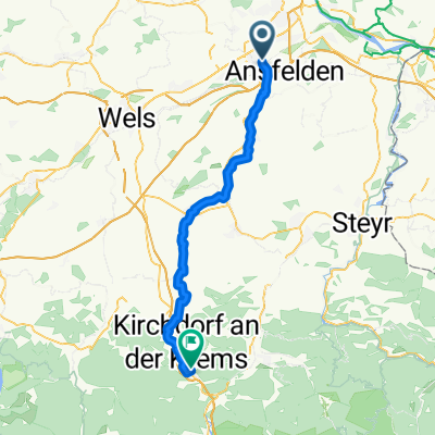
Nettingsdorf Ebersberg Ansfelden
A cycling route starting in Traun, Upper Austria, Austria.
Overview
About this route
- 1 h 6 min
- Duration
- 23.9 km
- Distance
- 106 m
- Ascent
- 107 m
- Descent
- 21.6 km/h
- Avg. speed
- ---
- Max. altitude

Route quality
Waytypes & surfaces along the route
Waytypes
Quiet road
8.3 km
(35 %)
Cycleway
7.6 km
(32 %)
Surfaces
Paved
13.9 km
(58 %)
Asphalt
13.7 km
(57 %)
Metal
0.1 km
(<1 %)
Continue with Bikemap
Use, edit, or download this cycling route
You would like to ride Nettingsdorf Ebersberg Ansfelden or customize it for your own trip? Here is what you can do with this Bikemap route:
Free features
- Save this route as favorite or in collections
- Copy & plan your own version of this route
- Sync your route with Garmin or Wahoo
Premium features
Free trial for 3 days, or one-time payment. More about Bikemap Premium.
- Navigate this route on iOS & Android
- Export a GPX / KML file of this route
- Create your custom printout (try it for free)
- Download this route for offline navigation
Discover more Premium features.
Get Bikemap PremiumFrom our community
Other popular routes starting in Traun
 Marchtrenk Runde
- Distance
- 24.9 km
- Ascent
- 47 m
- Descent
- 42 m
- Location
- Traun, Upper Austria, Austria
 Lessingstraße 3, Traun nach Lessingstraße 1, Traun
- Distance
- 7.5 km
- Ascent
- 36 m
- Descent
- 51 m
- Location
- Traun, Upper Austria, Austria
 Donau-Runde
- Distance
- 41.8 km
- Ascent
- 52 m
- Descent
- 52 m
- Location
- Traun, Upper Austria, Austria
 Fähre Mauthausen
- Distance
- 53.9 km
- Ascent
- 384 m
- Descent
- 383 m
- Location
- Traun, Upper Austria, Austria
 Traun goes Mühlviertel
- Distance
- 71.4 km
- Ascent
- 1,202 m
- Descent
- 1,190 m
- Location
- Traun, Upper Austria, Austria
 Kremstalradweg R10
- Distance
- 53.6 km
- Ascent
- 375 m
- Descent
- 185 m
- Location
- Traun, Upper Austria, Austria
 mit damili
- Distance
- 10.4 km
- Ascent
- 280 m
- Descent
- 288 m
- Location
- Traun, Upper Austria, Austria
 Ansfelden Wien
- Distance
- 229 km
- Ascent
- 947 m
- Descent
- 1,018 m
- Location
- Traun, Upper Austria, Austria
Open it in the app