

Aktivrunde 1
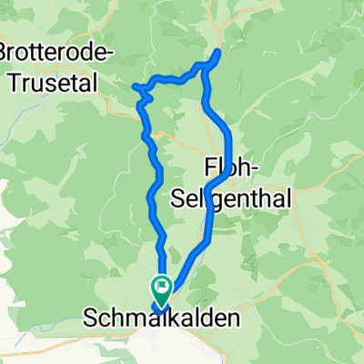
A cycling route starting in Schmalkalden, Thuringia, Germany.
Overview
About this route
Erleben Sie diese schöne Radrunde für Einsteiger direkt ab unseren Hotel.
Die Runde führt links ab dem Hotel zur Oberwallbachsmühle wo man an den Wochenenden und Feiertagen auch einkehren kann. Danach führt uns die Strecke über Metzels entlang dem Dolmargraben Richtung Christes. Auf der Christeser Höhe biegen wir links ab Richtung Schmalkalden und fahren oberhalb der Gemeinde Grumbach zurück zum Aktiv & Vital Hotel Thüringen.
- -:--
- Duration
- 20 km
- Distance
- 376 m
- Ascent
- 376 m
- Descent
- ---
- Avg. speed
- ---
- Max. altitude

Route quality
Waytypes & surfaces along the route
Waytypes
Track
17.7 km
(88 %)
Quiet road
1 km
(5 %)
Surfaces
Paved
5.4 km
(27 %)
Unpaved
13.5 km
(68 %)
Gravel
12.8 km
(64 %)
Asphalt
5.4 km
(27 %)
Continue with Bikemap
Use, edit, or download this cycling route
You would like to ride Aktivrunde 1 or customize it for your own trip? Here is what you can do with this Bikemap route:
Free features
- Save this route as favorite or in collections
- Copy & plan your own version of this route
- Sync your route with Garmin or Wahoo
Premium features
Free trial for 3 days, or one-time payment. More about Bikemap Premium.
- Navigate this route on iOS & Android
- Export a GPX / KML file of this route
- Create your custom printout (try it for free)
- Download this route for offline navigation
Discover more Premium features.
Get Bikemap PremiumFrom our community
Other popular routes starting in Schmalkalden
 Gieselsberg Runde
- Distance
- 19.5 km
- Ascent
- 381 m
- Descent
- 314 m
- Location
- Schmalkalden, Thuringia, Germany
 Thuringia 02: Schmalkalden - Eisenach
- Distance
- 96.1 km
- Ascent
- 369 m
- Descent
- 445 m
- Location
- Schmalkalden, Thuringia, Germany
 Mommelstein-Spießberg-Runde
- Distance
- 43.3 km
- Ascent
- 892 m
- Descent
- 754 m
- Location
- Schmalkalden, Thuringia, Germany
 Eisenach
- Distance
- 41.7 km
- Ascent
- 411 m
- Descent
- 503 m
- Location
- Schmalkalden, Thuringia, Germany
 Helmers - Köhlersberg - Wernshausen
- Distance
- 24.2 km
- Ascent
- 372 m
- Descent
- 372 m
- Location
- Schmalkalden, Thuringia, Germany
 Mittelstille - Kleiner Dolmar - Christes - Metzels - Walldorf - Werratalweg - Wernshausen - Schmalkalden
- Distance
- 46.2 km
- Ascent
- 455 m
- Descent
- 456 m
- Location
- Schmalkalden, Thuringia, Germany
 Schmalkalden-Rennsteig-Ebertswiese-Schmalkalden
- Distance
- 29.4 km
- Ascent
- 919 m
- Descent
- 919 m
- Location
- Schmalkalden, Thuringia, Germany
 Dolmarrunde
- Distance
- 32.7 km
- Ascent
- 669 m
- Descent
- 666 m
- Location
- Schmalkalden, Thuringia, Germany
Open it in the app