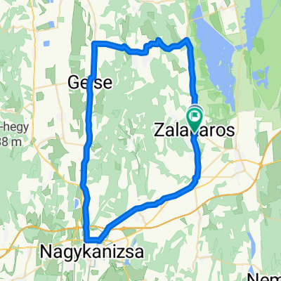
- 77.1 km
- 159 m
- 159 m
- Zalakomár, Zala County, Hungary
Mount Everest Plus/Források völgye túra
A cycling route starting in Zalakomár, Zala County, Hungary.
Overview
About this route
Two wheels, two feet and with your eyes open…
Along the Zala / Along the Zala / Along the Zala / Uz Zala / Ob Zala
Thematic tours / Thematic tours / Thematic tours / Tematski izleti
Nature / Nature / Nature / Priroda
Star Tour / Star Tour / Zvijezda / Zvezda Tour
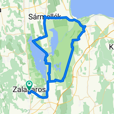
Mount Everest Tour / Mount Everest Tour / Mount Everest Tour /
The essence of the Mount Everest tour is that it takes you to a high elevation, the route plan is only for one way, and the distance is over 8 km. I freely use the name Mount Everest after my friend Imi Bősz.
- -:--
- Duration
- 11.4 km
- Distance
- 224 m
- Ascent
- 128 m
- Descent
- ---
- Avg. speed
- ---
- Max. altitude
created this 8 years ago
Route quality
Waytypes & surfaces along the route
Waytypes
Track
7.8 km
(68 %)
Path
1.5 km
(13 %)
Surfaces
Paved
2.1 km
(18 %)
Unpaved
5.4 km
(47 %)
Ground
5 km
(44 %)
Asphalt
2.1 km
(18 %)
Route highlights
Points of interest along the route
Point of interest after 3.4 km
.
Point of interest after 3.9 km
.
Point of interest after 4.3 km
.
Point of interest after 5.1 km
.
Point of interest after 6 km
Kanyar
Point of interest after 6.9 km
Gesztenyés ház
Point of interest after 7 km
.
Point of interest after 7.9 km
.
Point of interest after 9.2 km
.
Point of interest after 9.9 km
.
Point of interest after 10.1 km
.
Point of interest after 11.1 km
.
Point of interest after 11.4 km
Források völgye
Continue with Bikemap
Use, edit, or download this cycling route
You would like to ride Mount Everest Plus/Források völgye túra or customize it for your own trip? Here is what you can do with this Bikemap route:
Free features
- Save this route as favorite or in collections
- Copy & plan your own version of this route
- Sync your route with Garmin or Wahoo
Premium features
Free trial for 3 days, or one-time payment. More about Bikemap Premium.
- Navigate this route on iOS & Android
- Export a GPX / KML file of this route
- Create your custom printout (try it for free)
- Download this route for offline navigation
Discover more Premium features.
Get Bikemap PremiumFrom our community
Other popular routes starting in Zalakomár
- Zalakaros 1
- Irány az Erdész forrás a Víz világnapja alkalmából
- 10.9 km
- 196 m
- 195 m
- Zalakomár, Zala County, Hungary
- Mindent a szemnek, semmit a kéznek! Koratavaszi vadvirágos séta Zalakaros keleti lejtőin
- 2.1 km
- 48 m
- 48 m
- Zalakomár, Zala County, Hungary
- Mount Everest Plus/Források völgye túra
- 11.4 km
- 224 m
- 128 m
- Zalakomár, Zala County, Hungary
- 7 vezés teljesítmény túra
- 69.9 km
- 249 m
- 252 m
- Zalakomár, Zala County, Hungary
- Szabadics Ride – Company Challenge 2026 - 19. Mapei Tour de Zalakaros
- 37.6 km
- 121 m
- 117 m
- Zalakomár, Zala County, Hungary
- MERIDA Zalakaros országúti maraton 2014 - 127km
- 130.8 km
- 445 m
- 445 m
- Zalakomár, Zala County, Hungary
- Zalakaros 2
- 57.8 km
- 417 m
- 415 m
- Zalakomár, Zala County, Hungary
Open it in the app


