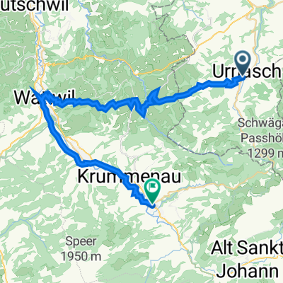
144_1730_Urnäsch-Appenzell-Bregenz-Wittenbach
A cycling route starting in Urnäsch, Canton of Appenzell Ausserrhoden, Switzerland.
Overview
About this route
Big ride on the road bike. The Hemberg at the end really requires some hard work.
- -:--
- Duration
- 143.8 km
- Distance
- 1,335 m
- Ascent
- 1,342 m
- Descent
- ---
- Avg. speed
- ---
- Max. altitude
Route quality
Waytypes & surfaces along the route
Waytypes
Road
44.6 km
(31 %)
Quiet road
27.3 km
(19 %)
Surfaces
Paved
112.1 km
(78 %)
Unpaved
7.2 km
(5 %)
Asphalt
107.8 km
(75 %)
Paved (undefined)
4.3 km
(3 %)
Continue with Bikemap
Use, edit, or download this cycling route
You would like to ride 144_1730_Urnäsch-Appenzell-Bregenz-Wittenbach or customize it for your own trip? Here is what you can do with this Bikemap route:
Free features
- Save this route as favorite or in collections
- Copy & plan your own version of this route
- Split it into stages to create a multi-day tour
- Sync your route with Garmin or Wahoo
Premium features
Free trial for 3 days, or one-time payment. More about Bikemap Premium.
- Navigate this route on iOS & Android
- Export a GPX / KML file of this route
- Create your custom printout (try it for free)
- Download this route for offline navigation
Discover more Premium features.
Get Bikemap PremiumFrom our community
Other popular routes starting in Urnäsch
- 096_1500_Urnäsch-Grabs-Schwägalp
- Distance
- 96 km
- Ascent
- 1,381 m
- Descent
- 1,377 m
- Location
- Urnäsch, Canton of Appenzell Ausserrhoden, Switzerland
- Urnäsch - Hochalp
- Distance
- 9.1 km
- Ascent
- 767 m
- Descent
- 75 m
- Location
- Urnäsch, Canton of Appenzell Ausserrhoden, Switzerland
- Rund um Kronberg
- Distance
- 41.3 km
- Ascent
- 1,429 m
- Descent
- 1,426 m
- Location
- Urnäsch, Canton of Appenzell Ausserrhoden, Switzerland
- Urnäsch,Appenzell, Ruppenpass, Eichberg, Oberriet, Buchs, Balzers, Luzisteig,, Maienfeld, Chur, Thusis
- Distance
- 124.5 km
- Ascent
- 1,462 m
- Descent
- 1,579 m
- Location
- Urnäsch, Canton of Appenzell Ausserrhoden, Switzerland
- Appenzellerstrasse 6, Urnäsch nach Kaustrasse 123, Appenzell
- Distance
- 52.8 km
- Ascent
- 2,412 m
- Descent
- 2,143 m
- Location
- Urnäsch, Canton of Appenzell Ausserrhoden, Switzerland
- Rund um den Kronberg
- Distance
- 38.9 km
- Ascent
- 737 m
- Descent
- 737 m
- Location
- Urnäsch, Canton of Appenzell Ausserrhoden, Switzerland
- Zweiter Tag 1.Route
- Distance
- 92.5 km
- Ascent
- 1,338 m
- Descent
- 1,345 m
- Location
- Urnäsch, Canton of Appenzell Ausserrhoden, Switzerland
- 144_1730_Urnäsch-Appenzell-Bregenz-Wittenbach
- Distance
- 143.8 km
- Ascent
- 1,335 m
- Descent
- 1,342 m
- Location
- Urnäsch, Canton of Appenzell Ausserrhoden, Switzerland
Open it in the app