

Haute Chaîne du Jura Marathon
A cycling route starting in Geneva, Canton of Geneva, Switzerland.
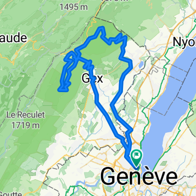
Overview
About this route
Parcours VTT offrant 90 km dans la Haute Chaîne du Jura, entre Crozet (Ain, France) et Juriens (Vaud, Suisse). Montée par la route forestière du col de Crozet, puis cap au nord-est à proximité de la ligne de crête : col de la Faucille, col de Combe Blanche, col de la Givrine, Combe des Amburnex, Mont Tendre Bike (Suisse à VTT 996), col du Mollendruz. Retour par le pied du Jura jusqu'à Aubonne, puis Rolle.
Distance : 142 km
Dénivelé positif : 2300 m
Altitude maximale : 1520 m (La Maréchaude)
Plus d'informations sur www.europebybike.info
- -:--
- Duration
- 140.9 km
- Distance
- 1,795 m
- Ascent
- 1,765 m
- Descent
- ---
- Avg. speed
- ---
- Max. altitude

Route highlights
Points of interest along the route
Point of interest after 7.4 km
Fontaine
Point of interest after 9.3 km
Fontaine
Point of interest after 14 km
Dernière fontaine avant le Jura
Point of interest after 45.1 km
col de La Faucille : café-restaurant et kiosque
Point of interest after 58.5 km
café-restaurant de Cuvaloup-de-Crans
Point of interest after 61.5 km
Gare de la Givrine : eau potable et toilettes
Point of interest after 66 km
chalet d'alpage du Vermeilley
Point of interest after 69.9 km
chalet d'alpage des Pralets
Point of interest after 79.2 km
café-restaurant du col du Marchairuz
Point of interest after 96.1 km
kiosque du col du Mollendruz
Continue with Bikemap
Use, edit, or download this cycling route
You would like to ride Haute Chaîne du Jura Marathon or customize it for your own trip? Here is what you can do with this Bikemap route:
Free features
- Save this route as favorite or in collections
- Copy & plan your own version of this route
- Split it into stages to create a multi-day tour
- Sync your route with Garmin or Wahoo
Premium features
Free trial for 3 days, or one-time payment. More about Bikemap Premium.
- Navigate this route on iOS & Android
- Export a GPX / KML file of this route
- Create your custom printout (try it for free)
- Download this route for offline navigation
Discover more Premium features.
Get Bikemap PremiumFrom our community
Other popular routes starting in Geneva
 Backside of the Jura, over Faucille, Marchairuz
- Distance
- 139 km
- Ascent
- 2,635 m
- Descent
- 2,595 m
- Location
- Geneva, Canton of Geneva, Switzerland
 Two cols 110 km nice hard ride
- Distance
- 118.1 km
- Ascent
- 2,037 m
- Descent
- 2,037 m
- Location
- Geneva, Canton of Geneva, Switzerland
 Bords du Rhône (Petit Parcours)
- Distance
- 35.6 km
- Ascent
- 417 m
- Descent
- 417 m
- Location
- Geneva, Canton of Geneva, Switzerland
 Day 1 Geneva to La Clusaz
- Distance
- 105.8 km
- Ascent
- 2,193 m
- Descent
- 1,533 m
- Location
- Geneva, Canton of Geneva, Switzerland
![29.08 [parcours valloné-roulant]](https://media.bikemap.net/routes/4408925/staticmaps/in_ef9e8f71-6a59-4ff9-a5ee-ab6aa312b752_400x400_bikemap-2021-3D-static.png) 29.08 [parcours valloné-roulant]
29.08 [parcours valloné-roulant]- Distance
- 93.7 km
- Ascent
- 439 m
- Descent
- 440 m
- Location
- Geneva, Canton of Geneva, Switzerland
 Pas de l'Echine
- Distance
- 84.8 km
- Ascent
- 1,707 m
- Descent
- 1,705 m
- Location
- Geneva, Canton of Geneva, Switzerland
 Loop Gva-Vesancy-Vesancy-Gex-Malval
- Distance
- 77.6 km
- Ascent
- 1,029 m
- Descent
- 998 m
- Location
- Geneva, Canton of Geneva, Switzerland
 25.11 WePerf
- Distance
- 72.5 km
- Ascent
- 380 m
- Descent
- 370 m
- Location
- Geneva, Canton of Geneva, Switzerland
Open it in the app