Mülheimer Str bis Ackerfährbrücke
A cycling route starting in Oberhausen, North Rhine-Westphalia, Germany.
Overview
About this route
Beautiful, predominantly traffic-calmed route. Easily manageable even with a city bike. About 15 km long
- -:--
- Duration
- 15.1 km
- Distance
- 21 m
- Ascent
- 24 m
- Descent
- ---
- Avg. speed
- 43 m
- Max. altitude
Route quality
Waytypes & surfaces along the route
Waytypes
Quiet road
5.4 km
(36 %)
Path
2.9 km
(19 %)
Surfaces
Paved
10.9 km
(72 %)
Unpaved
1.8 km
(12 %)
Asphalt
10.9 km
(72 %)
Gravel
1.2 km
(8 %)
Continue with Bikemap
Use, edit, or download this cycling route
You would like to ride Mülheimer Str bis Ackerfährbrücke or customize it for your own trip? Here is what you can do with this Bikemap route:
Free features
- Save this route as favorite or in collections
- Copy & plan your own version of this route
- Sync your route with Garmin or Wahoo
Premium features
Free trial for 3 days, or one-time payment. More about Bikemap Premium.
- Navigate this route on iOS & Android
- Export a GPX / KML file of this route
- Create your custom printout (try it for free)
- Download this route for offline navigation
Discover more Premium features.
Get Bikemap PremiumFrom our community
Other popular routes starting in Oberhausen
Tourenatlas Ruhrgebiet Tour 1- Distance
- 32.6 km
- Ascent
- 131 m
- Descent
- 148 m
- Location
- Oberhausen, North Rhine-Westphalia, Germany
Bahntrasse in Oberhausen- Distance
- 29.5 km
- Ascent
- 58 m
- Descent
- 70 m
- Location
- Oberhausen, North Rhine-Westphalia, Germany
Mülheimer Str bis Ackerfährbrücke- Distance
- 15.1 km
- Ascent
- 21 m
- Descent
- 24 m
- Location
- Oberhausen, North Rhine-Westphalia, Germany
Olga zur Ruhr und Baldeneysee- Distance
- 102.4 km
- Ascent
- 123 m
- Descent
- 119 m
- Location
- Oberhausen, North Rhine-Westphalia, Germany
Schönebeck-Baldeneysee- Distance
- 47.2 km
- Ascent
- 171 m
- Descent
- 173 m
- Location
- Oberhausen, North Rhine-Westphalia, Germany
OB-MH- Distance
- 11 km
- Ascent
- 31 m
- Descent
- 36 m
- Location
- Oberhausen, North Rhine-Westphalia, Germany
Runde 21 km- Distance
- 20.6 km
- Ascent
- 94 m
- Descent
- 87 m
- Location
- Oberhausen, North Rhine-Westphalia, Germany
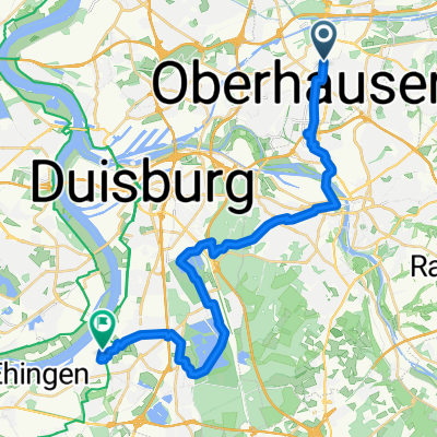
Oberhausen-Essen-Ruhr- Distance
- 27.2 km
- Ascent
- 221 m
- Descent
- 202 m
- Location
- Oberhausen, North Rhine-Westphalia, Germany
Open it in the app

