
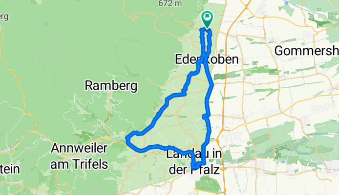
Godrammstein
A cycling route starting in Maikammer, Rhineland-Palatinate, Germany.
Overview
About this route
- -:--
- Duration
- 40.6 km
- Distance
- 223 m
- Ascent
- 223 m
- Descent
- ---
- Avg. speed
- ---
- Max. altitude

Continue with Bikemap
Use, edit, or download this cycling route
You would like to ride Godrammstein or customize it for your own trip? Here is what you can do with this Bikemap route:
Free features
- Save this route as favorite or in collections
- Copy & plan your own version of this route
- Sync your route with Garmin or Wahoo
Premium features
Free trial for 3 days, or one-time payment. More about Bikemap Premium.
- Navigate this route on iOS & Android
- Export a GPX / KML file of this route
- Create your custom printout (try it for free)
- Download this route for offline navigation
Discover more Premium features.
Get Bikemap PremiumFrom our community
Other popular routes starting in Maikammer
 Neustadt-kleine Runde
- Distance
- 21.9 km
- Ascent
- 98 m
- Descent
- 98 m
- Location
- Maikammer, Rhineland-Palatinate, Germany
 Südpfalz 1
- Distance
- 35.4 km
- Ascent
- 305 m
- Descent
- 307 m
- Location
- Maikammer, Rhineland-Palatinate, Germany
 Flache Abendrunde
- Distance
- 27.9 km
- Ascent
- 79 m
- Descent
- 81 m
- Location
- Maikammer, Rhineland-Palatinate, Germany
 Kalmitrunde
- Distance
- 15.8 km
- Ascent
- 443 m
- Descent
- 443 m
- Location
- Maikammer, Rhineland-Palatinate, Germany
 Godrammstein
- Distance
- 40.6 km
- Ascent
- 223 m
- Descent
- 223 m
- Location
- Maikammer, Rhineland-Palatinate, Germany
 Hohe Loog, Kalmit, Edenkobener Tal
- Distance
- 30 km
- Ascent
- 657 m
- Descent
- 586 m
- Location
- Maikammer, Rhineland-Palatinate, Germany
 Wxiodwwxidwfwxwxidwwwiwfwwfiwoooooowfowfaofowgwowowfowifowfuwfwfwwfowwowoiwfifdww
- Distance
- 45.2 km
- Ascent
- 211 m
- Descent
- 278 m
- Location
- Maikammer, Rhineland-Palatinate, Germany
 Von Maikammer bis Nierstein
- Distance
- 98 km
- Ascent
- 390 m
- Descent
- 475 m
- Location
- Maikammer, Rhineland-Palatinate, Germany
Open it in the app