
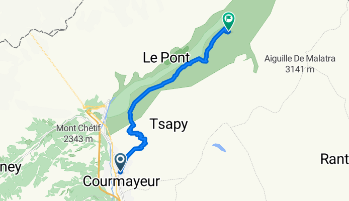
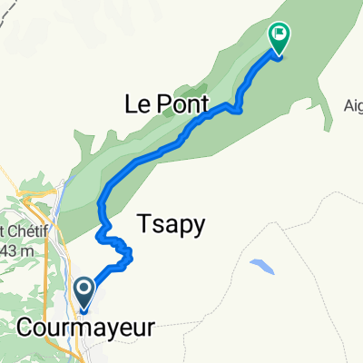
Courmayeur-Rif.Bonatti
A cycling route starting in Courmayeur, Aosta Valley, Italy.
Overview
About this route
excursion from the center of Courmayeur
- -:--
- Duration
- 11.7 km
- Distance
- 1,009 m
- Ascent
- 213 m
- Descent
- ---
- Avg. speed
- ---
- Max. altitude
Continue with Bikemap
Use, edit, or download this cycling route
You would like to ride Courmayeur-Rif.Bonatti or customize it for your own trip? Here is what you can do with this Bikemap route:
Free features
- Save this route as favorite or in collections
- Copy & plan your own version of this route
- Sync your route with Garmin or Wahoo
Premium features
Free trial for 3 days, or one-time payment. More about Bikemap Premium.
- Navigate this route on iOS & Android
- Export a GPX / KML file of this route
- Create your custom printout (try it for free)
- Download this route for offline navigation
Discover more Premium features.
Get Bikemap PremiumFrom our community
Other popular routes starting in Courmayeur
 Courmayeur To Val Ferret
- Distance
- 40.4 km
- Ascent
- 1,067 m
- Descent
- 1,057 m
- Location
- Courmayeur, Aosta Valley, Italy
 GRAN FONDO MONTE BIANCO
- Distance
- 129.3 km
- Ascent
- 2,993 m
- Descent
- 2,991 m
- Location
- Courmayeur, Aosta Valley, Italy
 Td98_9. den Courmayeur - Arona
- Distance
- 196.3 km
- Ascent
- 738 m
- Descent
- 1,767 m
- Location
- Courmayeur, Aosta Valley, Italy
 Tour del Monte Bianco
- Distance
- 199 km
- Ascent
- 9,314 m
- Descent
- 9,314 m
- Location
- Courmayeur, Aosta Valley, Italy
 Courmayeur-Rif.Bonatti
- Distance
- 11.7 km
- Ascent
- 1,009 m
- Descent
- 213 m
- Location
- Courmayeur, Aosta Valley, Italy
 Les Droites 6
- Distance
- 134.2 km
- Ascent
- 6,206 m
- Descent
- 4,335 m
- Location
- Courmayeur, Aosta Valley, Italy
 Bonatti-Bertone
- Distance
- 15.1 km
- Ascent
- 936 m
- Descent
- 817 m
- Location
- Courmayeur, Aosta Valley, Italy
 TMB day 3
- Distance
- 33.8 km
- Ascent
- 1,838 m
- Descent
- 1,561 m
- Location
- Courmayeur, Aosta Valley, Italy
Open it in the app