

Dia 8 Tentoland - Gokazan Park
A cycling route starting in Abashiri, Hokkaido, Japan.
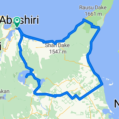
Overview
About this route
- -:--
- Duration
- 79.8 km
- Distance
- 360 m
- Ascent
- 360 m
- Descent
- ---
- Avg. speed
- ---
- Max. altitude

Route highlights
Points of interest along the route
Point of interest after 5.6 km
Inici via verda fins a Tokoro
Point of interest after 47.9 km
Kimuaneppumisaki Camping
Point of interest after 51.4 km
Cafeteria
Point of interest after 67.6 km
Family Land. Cafè, wc.
Continue with Bikemap
Use, edit, or download this cycling route
You would like to ride Dia 8 Tentoland - Gokazan Park or customize it for your own trip? Here is what you can do with this Bikemap route:
Free features
- Save this route as favorite or in collections
- Copy & plan your own version of this route
- Sync your route with Garmin or Wahoo
Premium features
Free trial for 3 days, or one-time payment. More about Bikemap Premium.
- Navigate this route on iOS & Android
- Export a GPX / KML file of this route
- Create your custom printout (try it for free)
- Download this route for offline navigation
Discover more Premium features.
Get Bikemap PremiumFrom our community
Other popular routes starting in Abashiri
 網走-留邊藥
- Distance
- 75.5 km
- Ascent
- 356 m
- Descent
- 162 m
- Location
- Abashiri, Hokkaido, Japan
 Dia 8 Tentoland - Gokazan Park
- Distance
- 79.8 km
- Ascent
- 360 m
- Descent
- 360 m
- Location
- Abashiri, Hokkaido, Japan
 D10-常呂黑川旅社國設知床營地
- Distance
- 115.4 km
- Ascent
- 213 m
- Descent
- 160 m
- Location
- Abashiri, Hokkaido, Japan
 2013-6月日本行第一日網走-----------阿寒湖
- Distance
- 84.6 km
- Ascent
- 670 m
- Descent
- 247 m
- Location
- Abashiri, Hokkaido, Japan
 Day12 網走 - 知床
- Distance
- 83.8 km
- Ascent
- 230 m
- Descent
- 166 m
- Location
- Abashiri, Hokkaido, Japan
 Hokkaido
- Distance
- 375.3 km
- Ascent
- 1,431 m
- Descent
- 1,434 m
- Location
- Abashiri, Hokkaido, Japan
 Memanbetsu
- Distance
- 35.3 km
- Ascent
- 238 m
- Descent
- 214 m
- Location
- Abashiri, Hokkaido, Japan
 Shiretoko Loop
- Distance
- 349.7 km
- Ascent
- 1,955 m
- Descent
- 1,955 m
- Location
- Abashiri, Hokkaido, Japan
Open it in the app