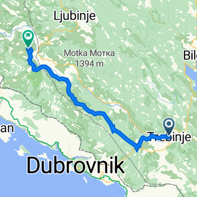
2017.06.20 Bosnia - Montenegro | Trebinje - Morinj
A cycling route starting in Trebinje, Republika Srpska, Bosnia and Herzegovina.
Overview
About this route
- -:--
- Duration
- 60.4 km
- Distance
- 753 m
- Ascent
- 1,028 m
- Descent
- ---
- Avg. speed
- ---
- Avg. speed
Route quality
Waytypes & surfaces along the route
Waytypes
Busy road
52.6 km
(87 %)
Quiet road
6.8 km
(11 %)
Surfaces
Paved
57.4 km
(95 %)
Asphalt
57 km
(94 %)
Concrete
0.4 km
(<1 %)
Undefined
3.1 km
(5 %)
Continue with Bikemap
Use, edit, or download this cycling route
You would like to ride 2017.06.20 Bosnia - Montenegro | Trebinje - Morinj or customize it for your own trip? Here is what you can do with this Bikemap route:
Free features
- Save this route as favorite or in collections
- Copy & plan your own version of this route
- Sync your route with Garmin or Wahoo
Premium features
Free trial for 3 days, or one-time payment. More about Bikemap Premium.
- Navigate this route on iOS & Android
- Export a GPX / KML file of this route
- Create your custom printout (try it for free)
- Download this route for offline navigation
Discover more Premium features.
Get Bikemap PremiumFrom our community
Other popular routes starting in Trebinje
- Trebinje - Meljine kružni tok
- Distance
- 41.6 km
- Ascent
- 652 m
- Descent
- 923 m
- Location
- Trebinje, Republika Srpska, Bosnia and Herzegovina
- Tour 2018 Tag 10
- Distance
- 71.2 km
- Ascent
- 706 m
- Descent
- 977 m
- Location
- Trebinje, Republika Srpska, Bosnia and Herzegovina
- Zasad polje, Trebinje to Unnamed Road
- Distance
- 6 km
- Ascent
- 34 m
- Descent
- 38 m
- Location
- Trebinje, Republika Srpska, Bosnia and Herzegovina
- 01 Trebinje to Herceg Novi
- Distance
- 58.1 km
- Ascent
- 1,285 m
- Descent
- 1,559 m
- Location
- Trebinje, Republika Srpska, Bosnia and Herzegovina
- Vrh Leotara
- Distance
- 13.2 km
- Ascent
- 1,110 m
- Descent
- 185 m
- Location
- Trebinje, Republika Srpska, Bosnia and Herzegovina
- 10. Tag Trebinj Slano
- Distance
- 70.9 km
- Ascent
- 667 m
- Descent
- 916 m
- Location
- Trebinje, Republika Srpska, Bosnia and Herzegovina
- Slow ride
- Distance
- 2.3 km
- Ascent
- 0 m
- Descent
- 41 m
- Location
- Trebinje, Republika Srpska, Bosnia and Herzegovina
- gggggggggggggggggggggg
- Distance
- 88.4 km
- Ascent
- 811 m
- Descent
- 1,088 m
- Location
- Trebinje, Republika Srpska, Bosnia and Herzegovina
Open it in the app