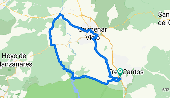
TRES CANTOS (FFCC)- P. LA MARMOTA-TRES CANTOS
A cycling route starting in Tres Cantos, Madrid, Spain.
Overview
About this route
- -:--
- Duration
- 40.6 km
- Distance
- 665 m
- Ascent
- 666 m
- Descent
- ---
- Avg. speed
- ---
- Max. altitude
Route highlights
Points of interest along the route
Point of interest after 6.8 km
Photo after 10.4 km
Photo after 11.3 km
Photo after 11.3 km
Photo after 11.5 km
Photo after 12.5 km
Photo after 17.8 km
Photo after 21.2 km
Photo after 22.2 km
Photo after 31.3 km
Photo after 40.3 km
Continue with Bikemap
Use, edit, or download this cycling route
You would like to ride TRES CANTOS (FFCC)- P. LA MARMOTA-TRES CANTOS or customize it for your own trip? Here is what you can do with this Bikemap route:
Free features
- Save this route as favorite or in collections
- Copy & plan your own version of this route
- Sync your route with Garmin or Wahoo
Premium features
Free trial for 3 days, or one-time payment. More about Bikemap Premium.
- Navigate this route on iOS & Android
- Export a GPX / KML file of this route
- Create your custom printout (try it for free)
- Download this route for offline navigation
Discover more Premium features.
Get Bikemap PremiumFrom our community
Other popular routes starting in Tres Cantos
- Tres Cantos-Puente de la Marmota-Colmenar
- Distance
- 45.7 km
- Ascent
- 565 m
- Descent
- 558 m
- Location
- Tres Cantos, Madrid, Spain
- Tres Cantos - Pte. Marmota - Pte. Presa - Colmenar - Tres Cantos
- Distance
- 45.8 km
- Ascent
- 680 m
- Descent
- 680 m
- Location
- Tres Cantos, Madrid, Spain
- Vuelta al Soto de Viñuelas
- Distance
- 32.1 km
- Ascent
- 300 m
- Descent
- 300 m
- Location
- Tres Cantos, Madrid, Spain
- Tres Cantos - Canal Bajo - Canal Alto - Tres Cantos
- Distance
- 46.2 km
- Ascent
- 425 m
- Descent
- 425 m
- Location
- Tres Cantos, Madrid, Spain
- Valla de Soto (modificada)
- Distance
- 45.5 km
- Ascent
- 344 m
- Descent
- 330 m
- Location
- Tres Cantos, Madrid, Spain
- Tres Cantos-Pico de la Marmota
- Distance
- 26.9 km
- Ascent
- 374 m
- Descent
- 376 m
- Location
- Tres Cantos, Madrid, Spain
- Tres Cantos - Cerro San Pedro (I- Ruta)
- Distance
- 45.8 km
- Ascent
- 433 m
- Descent
- 433 m
- Location
- Tres Cantos, Madrid, Spain
- De Tres Cantos a Madrid Río por El Pardo
- Distance
- 39.3 km
- Ascent
- 113 m
- Descent
- 272 m
- Location
- Tres Cantos, Madrid, Spain
Open it in the app