

Overview
About this route
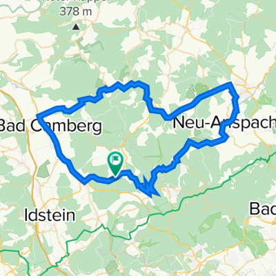
Rennradtaugliche, traumhaft schöne Rundfahrt durch die malerischten Winkel des Hochtaunus Gebiets.
Nach einem schattigen und knackigen Anstieg hinauf zum Großen Feldberg geht es über Schmitten kurvenreich entspannt und ruhig durch das Weiltal dahin bevor uns der Rückweg über Bad Camberg nach Niederems noch einige "Nehmerqualitäten" im extrem hügeligen Gelände abverlangt. Dabei werden wir von überwiegend ruhigen Nebenstraßen durch eine wunderbare, bewaldete Hügellandschaft geleitet.
Ein absolutes must-ride!
- -:--
- Duration
- 82.4 km
- Distance
- 1,172 m
- Ascent
- 1,171 m
- Descent
- ---
- Avg. speed
- ---
- Max. altitude
Part of
Hessen - Taunus
1 stage
Route quality
Waytypes & surfaces along the route
Waytypes
Busy road
48.4 km
(59 %)
Track
11.9 km
(14 %)
Surfaces
Paved
52.3 km
(64 %)
Unpaved
6.8 km
(8 %)
Asphalt
48 km
(58 %)
Ground
2.8 km
(3 %)
Continue with Bikemap
Use, edit, or download this cycling route
You would like to ride Highlife im Hochtaunus or customize it for your own trip? Here is what you can do with this Bikemap route:
Free features
- Save this route as favorite or in collections
- Copy & plan your own version of this route
- Split it into stages to create a multi-day tour
- Sync your route with Garmin or Wahoo
Premium features
Free trial for 3 days, or one-time payment. More about Bikemap Premium.
- Navigate this route on iOS & Android
- Export a GPX / KML file of this route
- Create your custom printout (try it for free)
- Download this route for offline navigation
Discover more Premium features.
Get Bikemap PremiumFrom our community
Other popular routes starting in Waldems
 Rundweg
- Distance
- 16.7 km
- Ascent
- 317 m
- Descent
- 317 m
- Location
- Waldems, Hesse, Germany
 Runde bei Idstein Heftrich durch den Wald
- Distance
- 6.1 km
- Ascent
- 162 m
- Descent
- 162 m
- Location
- Waldems, Hesse, Germany
 Kleine Weiltalrunde
- Distance
- 57.3 km
- Ascent
- 559 m
- Descent
- 559 m
- Location
- Waldems, Hesse, Germany
 Reichenbach-Beuerbach-Ohren-Ketternschwalbach-Wallrabenstein-Würges-Reichenbach
- Distance
- 52.6 km
- Ascent
- 819 m
- Descent
- 821 m
- Location
- Waldems, Hesse, Germany
 Runde Weilmünster
- Distance
- 58.3 km
- Ascent
- 677 m
- Descent
- 677 m
- Location
- Waldems, Hesse, Germany
 Altkönig-Gipfel
- Distance
- 16.6 km
- Ascent
- 510 m
- Descent
- 173 m
- Location
- Waldems, Hesse, Germany
 Hölle Taunus
- Distance
- 61.6 km
- Ascent
- 839 m
- Descent
- 836 m
- Location
- Waldems, Hesse, Germany
 Altkönig Gipfel
- Distance
- 16.5 km
- Ascent
- 513 m
- Descent
- 187 m
- Location
- Waldems, Hesse, Germany
Open it in the app