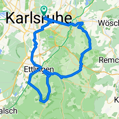
durch die Vorderpfalz
A cycling route starting in Karlsruhe, Baden-Wurttemberg, Germany.
Overview
About this route
very flat tour over remote roads through beautiful forests and along the Rhine.
- -:--
- Duration
- 69.7 km
- Distance
- 141 m
- Ascent
- 150 m
- Descent
- ---
- Avg. speed
- 161 m
- Max. altitude
Route quality
Waytypes & surfaces along the route
Waytypes
Road
15.3 km
(22 %)
Path
13.2 km
(19 %)
Surfaces
Paved
59.9 km
(86 %)
Unpaved
2.8 km
(4 %)
Asphalt
57.1 km
(82 %)
Concrete
2.1 km
(3 %)
Continue with Bikemap
Use, edit, or download this cycling route
You would like to ride durch die Vorderpfalz or customize it for your own trip? Here is what you can do with this Bikemap route:
Free features
- Save this route as favorite or in collections
- Copy & plan your own version of this route
- Sync your route with Garmin or Wahoo
Premium features
Free trial for 3 days, or one-time payment. More about Bikemap Premium.
- Navigate this route on iOS & Android
- Export a GPX / KML file of this route
- Create your custom printout (try it for free)
- Download this route for offline navigation
Discover more Premium features.
Get Bikemap PremiumFrom our community
Other popular routes starting in Karlsruhe
Durlach-Pfinztal Runde- Distance
- 39.3 km
- Ascent
- 413 m
- Descent
- 406 m
- Location
- Karlsruhe, Baden-Wurttemberg, Germany
Kreuzung Adenauerring / Grabener Allee zur Insel Rott- Distance
- 16.5 km
- Ascent
- 17 m
- Descent
- 37 m
- Location
- Karlsruhe, Baden-Wurttemberg, Germany
KA - Durlach - Wattkopf - Muschelbach - Thomashof - KA- Distance
- 48.9 km
- Ascent
- 656 m
- Descent
- 654 m
- Location
- Karlsruhe, Baden-Wurttemberg, Germany
n bisschen Schwarzwald- Distance
- 55.4 km
- Ascent
- 670 m
- Descent
- 656 m
- Location
- Karlsruhe, Baden-Wurttemberg, Germany
Karlsruhe - Speyer- Distance
- 50.3 km
- Ascent
- 88 m
- Descent
- 104 m
- Location
- Karlsruhe, Baden-Wurttemberg, Germany
KA: Abendlicher Rundkurs +/- 1h 15min- Distance
- 30.5 km
- Ascent
- 51 m
- Descent
- 49 m
- Location
- Karlsruhe, Baden-Wurttemberg, Germany
KA: Traingsrundentestfahrt- Distance
- 34.7 km
- Ascent
- 49 m
- Descent
- 47 m
- Location
- Karlsruhe, Baden-Wurttemberg, Germany
Karlsruhe - Turmberg - Stupferich - Mutschelbach - Langensteinbach - Ittersbach - Schöllbronn - Ettlingen - Karlsruhe- Distance
- 59 km
- Ascent
- 514 m
- Descent
- 515 m
- Location
- Karlsruhe, Baden-Wurttemberg, Germany
Open it in the app

