Eningen - Lautertal
A cycling route starting in Eningen unter Achalm, Baden-Württemberg, Germany.
Overview
About this route
Meist abseits der Straßen
- -:--
- Duration
- 95.7 km
- Distance
- 1,327 m
- Ascent
- 1,360 m
- Descent
- ---
- Avg. speed
- 793 m
- Avg. speed
Route quality
Waytypes & surfaces along the route
Waytypes
Track
53.2 km
(56 %)
Quiet road
17.6 km
(18 %)
Surfaces
Paved
69.4 km
(72 %)
Unpaved
21.5 km
(23 %)
Asphalt
65.4 km
(68 %)
Gravel
17.2 km
(18 %)
Continue with Bikemap
Use, edit, or download this cycling route
You would like to ride Eningen - Lautertal or customize it for your own trip? Here is what you can do with this Bikemap route:
Free features
- Save this route as favorite or in collections
- Copy & plan your own version of this route
- Sync your route with Garmin or Wahoo
Premium features
Free trial for 3 days, or one-time payment. More about Bikemap Premium.
- Navigate this route on iOS & Android
- Export a GPX / KML file of this route
- Create your custom printout (try it for free)
- Download this route for offline navigation
Discover more Premium features.
Get Bikemap PremiumFrom our community
Other popular routes starting in Eningen unter Achalm
- 2018-08 Eningen-Ulm
- Distance
- 71 km
- Ascent
- 675 m
- Descent
- 634 m
- Location
- Eningen unter Achalm, Baden-Württemberg, Germany
- Eningen - Lautertal
- Distance
- 95.7 km
- Ascent
- 1,327 m
- Descent
- 1,360 m
- Location
- Eningen unter Achalm, Baden-Württemberg, Germany
- Eningen - Bad Cannstatt
- Distance
- 105.4 km
- Ascent
- ---
- Descent
- ---
- Location
- Eningen unter Achalm, Baden-Württemberg, Germany
- Trainingsrunde 02 (Wadenbeißer - Tour)
- Distance
- 72.5 km
- Ascent
- 976 m
- Descent
- 976 m
- Location
- Eningen unter Achalm, Baden-Württemberg, Germany
- Glems auf die Alb
- Distance
- 60.1 km
- Ascent
- 0 m
- Descent
- 0 m
- Location
- Eningen unter Achalm, Baden-Württemberg, Germany
- Eningen-Schonach
- Distance
- 138.2 km
- Ascent
- 1,054 m
- Descent
- 578 m
- Location
- Eningen unter Achalm, Baden-Württemberg, Germany
- Eningen - Alb - Eningen
- Distance
- 47.4 km
- Ascent
- 760 m
- Descent
- 656 m
- Location
- Eningen unter Achalm, Baden-Württemberg, Germany
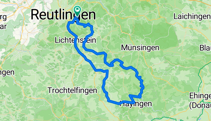
- Reutlinger Radtour zum Mädlesfels und über Bad Urach zurück
- Distance
- 46.1 km
- Ascent
- 642 m
- Descent
- 640 m
- Location
- Eningen unter Achalm, Baden-Württemberg, Germany
Open it in the app