

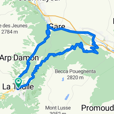
Loop around La Thuile ski station
A cycling route starting in La Thuile, Aosta Valley, Italy.
Overview
About this route
Long climb up fire roads followed by interesting descent.
- -:--
- Duration
- 23.6 km
- Distance
- 1,015 m
- Ascent
- 998 m
- Descent
- ---
- Avg. speed
- ---
- Max. altitude
Continue with Bikemap
Use, edit, or download this cycling route
You would like to ride Loop around La Thuile ski station or customize it for your own trip? Here is what you can do with this Bikemap route:
Free features
- Save this route as favorite or in collections
- Copy & plan your own version of this route
- Sync your route with Garmin or Wahoo
Premium features
Free trial for 3 days, or one-time payment. More about Bikemap Premium.
- Navigate this route on iOS & Android
- Export a GPX / KML file of this route
- Create your custom printout (try it for free)
- Download this route for offline navigation
Discover more Premium features.
Get Bikemap PremiumFrom our community
Other popular routes starting in La Thuile
 La Thuile - Col de l'Iseran e ritorno
- Distance
- 69.6 km
- Ascent
- 2,450 m
- Descent
- 1,130 m
- Location
- La Thuile, Aosta Valley, Italy
 La Thuile - Creta con ciaspole
- Distance
- 8.3 km
- Ascent
- 954 m
- Descent
- 959 m
- Location
- La Thuile, Aosta Valley, Italy
 2012: piccolo s.bernardo - passy
- Distance
- 184.6 km
- Ascent
- 1,959 m
- Descent
- 3,559 m
- Location
- La Thuile, Aosta Valley, Italy
 LTH-Morgex-Colle San Carlo-LTH
- Distance
- 30.9 km
- Ascent
- 1,016 m
- Descent
- 1,016 m
- Location
- La Thuile, Aosta Valley, Italy
 La Thuille P.S. Bernardo
- Distance
- 13.5 km
- Ascent
- 804 m
- Descent
- 61 m
- Location
- La Thuile, Aosta Valley, Italy
 LTH-Mont Chaz Dura-Piccolo S. Bernardo-LTH
- Distance
- 30.5 km
- Ascent
- 1,072 m
- Descent
- 1,081 m
- Location
- La Thuile, Aosta Valley, Italy
 9 tappa traversata delle alpi
- Distance
- 136.1 km
- Ascent
- 2,274 m
- Descent
- 3,020 m
- Location
- La Thuile, Aosta Valley, Italy
 LTH-Les Suches-Le Foyer-LTH
- Distance
- 23.4 km
- Ascent
- 857 m
- Descent
- 847 m
- Location
- La Thuile, Aosta Valley, Italy
Open it in the app