

Schillingsfürst ---> Schaffhausen (CH)
A cycling route starting in Schillingsfürst, Bavaria, Germany.
Overview
About this route
- -:--
- Duration
- 503.6 km
- Distance
- 711 m
- Ascent
- 791 m
- Descent
- ---
- Avg. speed
- ---
- Max. altitude

Route highlights
Points of interest along the route
\"")
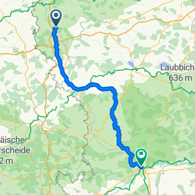
Point of interest after 101.2 km
\"")
Point of interest after 117 km
Erste Übernachtung Campingplatz Rammingen
\"")
Point of interest after 135.3 km
Point of interest after 209.9 km
Zweite Übernachtung nach regnerischen Tag
\"")
Point of interest after 311.9 km
Dritte Übernachtung Immendingen Donauversickerung
\"")
Point of interest after 424.6 km
Letzte Übernachtung Supercamping direkt am See
Point of interest after 487 km
Mittagsrast am Rhein
\"")
Point of interest after 497.2 km
Point of interest after 503.5 km
Ziel: Behringen am Randen
Continue with Bikemap
Use, edit, or download this cycling route
You would like to ride Schillingsfürst ---> Schaffhausen (CH) or customize it for your own trip? Here is what you can do with this Bikemap route:
Free features
- Save this route as favorite or in collections
- Copy & plan your own version of this route
- Split it into stages to create a multi-day tour
- Sync your route with Garmin or Wahoo
Premium features
Free trial for 3 days, or one-time payment. More about Bikemap Premium.
- Navigate this route on iOS & Android
- Export a GPX / KML file of this route
- Create your custom printout (try it for free)
- Download this route for offline navigation
Discover more Premium features.
Get Bikemap PremiumFrom our community
Other popular routes starting in Schillingsfürst
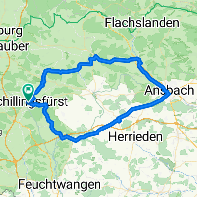
 Der Wörnitzradweg
- Distance
- 106.3 km
- Ascent
- 364 m
- Descent
- 458 m
- Location
- Schillingsfürst, Bavaria, Germany
 Schillingsfürst ---> Schaffhausen (CH)
- Distance
- 503.6 km
- Ascent
- 711 m
- Descent
- 791 m
- Location
- Schillingsfürst, Bavaria, Germany
 Sch --> Nürnberg Aug 2009
- Distance
- 79.4 km
- Ascent
- 377 m
- Descent
- 601 m
- Location
- Schillingsfürst, Bavaria, Germany
 Mittlere Trainingsstrecke
- Distance
- 33.3 km
- Ascent
- 318 m
- Descent
- 312 m
- Location
- Schillingsfürst, Bavaria, Germany
 B2-11/B12c: Schillingsfürst - Fremdingen, 66,1km 550hm
- Distance
- 66.1 km
- Ascent
- 671 m
- Descent
- 720 m
- Location
- Schillingsfürst, Bavaria, Germany
 Tagestour 1 St - Großheubach (Schillingsfürst - Hamburg)
- Distance
- 149.1 km
- Ascent
- 1,810 m
- Descent
- 2,176 m
- Location
- Schillingsfürst, Bavaria, Germany
 Schillingsfürst, Kloster Sulz, Aurach, Ansbach, Lehrberg, Colmberg, Schillingsfürstrholz, Leutershausen, Schillingsfürst
- Distance
- 65.5 km
- Ascent
- 568 m
- Descent
- 565 m
- Location
- Schillingsfürst, Bavaria, Germany
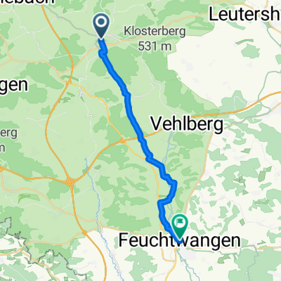 From Schillingsfürst to Feuchtwangen
- Distance
- 16.9 km
- Ascent
- 118 m
- Descent
- 174 m
- Location
- Schillingsfürst, Bavaria, Germany
Open it in the app