

9. Cascada Vălul Miresei și Muntele Vlădeasa
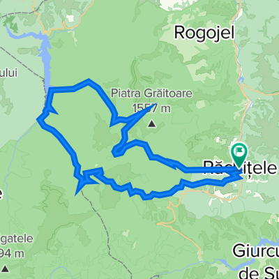
A cycling route starting in Mărgău, Cluj County, Romania.
Overview
About this route
The Vlădeasa Massif is the most impressive in the north of the Apuseni Mountains, but it is crisscrossed by many tracks. This route includes an extension along the massif ridge, recommended only for those with advanced fitness, as climbing and descending the ridge requires significant effort.
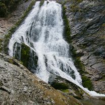
The starting point is the village of Răchițele, and the first part of the route follows the road to Valul Miresei waterfall. The stream is followed for another 5.5 km, then the route heads northeast toward the Pietrele Albe viewpoint. In the clearings on the climb there are some sheepfolds, often with dogs present.
From Pietrele Albe, you can begin the optional extra section. Follow the red stripe markings to the summit, then descend to Cabana Vlădeasa and rejoin the main route on the blue stripe trail heading south. The climb covers 310 meters of elevation over 2 km. The descent is similar and can be dangerous.
The standard route follows the trail below the ridge for 2 km and then veers east on a descent to the village of Scrind-Frăsinet. In the clearing to the right, a dirt road begins with a gentle slope but becomes tougher as you enter the forest. The steep slope and large stones can be difficult, so extra caution is advised. After the first clearing, the track improves and the descent becomes enjoyable.
It is very important to stay on the ridge road and avoid any tracks dropping into the valleys. Before the first houses, the road briefly enters the woods. Watch out for the fence bordering the track! It blocks the way in two places but is intended for livestock. Carefully cross these improvised gates and always close them after passing.
You pass through part of the village, then the route enters the forest and emerges onto pavement 500 meters from the intersection with the road back to Răchițele (5 km).
- -:--
- Duration
- 29 km
- Distance
- 916 m
- Ascent
- 914 m
- Descent
- ---
- Avg. speed
- ---
- Max. altitude

Route photos


Route quality
Waytypes & surfaces along the route
Waytypes
Track
20 km
(69 %)
Quiet road
4.1 km
(14 %)
Surfaces
Paved
7.8 km
(27 %)
Unpaved
14.2 km
(49 %)
Gravel
9.9 km
(34 %)
Asphalt
7.8 km
(27 %)
Route highlights
Points of interest along the route

Point of interest after 6 km
Cascada Vălul Miresei

Point of interest after 12.3 km

Point of interest after 12.9 km

Point of interest after 15.3 km

Point of interest after 17.8 km
Continue with Bikemap
Use, edit, or download this cycling route
You would like to ride 9. Cascada Vălul Miresei și Muntele Vlădeasa or customize it for your own trip? Here is what you can do with this Bikemap route:
Free features
- Save this route as favorite or in collections
- Copy & plan your own version of this route
- Sync your route with Garmin or Wahoo
Premium features
Free trial for 3 days, or one-time payment. More about Bikemap Premium.
- Navigate this route on iOS & Android
- Export a GPX / KML file of this route
- Create your custom printout (try it for free)
- Download this route for offline navigation
Discover more Premium features.
Get Bikemap PremiumFrom our community
Other popular routes starting in Mărgău
 9. Cascada Vălul Miresei și Muntele Vlădeasa
- Distance
- 29 km
- Ascent
- 916 m
- Descent
- 914 m
- Location
- Mărgău, Cluj County, Romania
 14. Circuit cascada Răchițele
- Distance
- 12.8 km
- Ascent
- 529 m
- Descent
- 528 m
- Location
- Mărgău, Cluj County, Romania
 Rachitele - Lacul Dragan - Nimaiasa (Mediu)
- Distance
- 49.8 km
- Ascent
- 1,502 m
- Descent
- 1,503 m
- Location
- Mărgău, Cluj County, Romania
 Valea Stanciului
- Distance
- 11.1 km
- Ascent
- 530 m
- Descent
- 110 m
- Location
- Mărgău, Cluj County, Romania
 Cabana Dealu Rasinarilor - Vf Caciulata - Dealu Boti
- Distance
- 14.2 km
- Ascent
- 659 m
- Descent
- 664 m
- Location
- Mărgău, Cluj County, Romania
 Rachitele,Piatra Arsa,Pietrele Albe
- Distance
- 22.9 km
- Ascent
- 765 m
- Descent
- 759 m
- Location
- Mărgău, Cluj County, Romania
 Rachitele - Doda Pilii - Dealu Botii- Rachitele
- Distance
- 30.8 km
- Ascent
- 712 m
- Descent
- 712 m
- Location
- Mărgău, Cluj County, Romania
 Rachitele - Lacul Dragan - Nimaiasa (Lung)
- Distance
- 62.6 km
- Ascent
- 1,976 m
- Descent
- 1,977 m
- Location
- Mărgău, Cluj County, Romania
Open it in the app