Beliş-Fântânele
- 5.2 km
- 348 m
- 389 m
- Beliş, Cluj County, Romania
A cycling route starting in Beliş, Cluj County, Romania.
Overview
One of the highest peaks in the Apuseni Mountains is a true challenge for any self-respecting cyclist. Reaching a maximum altitude of just over 1,700 meters, this route features an elevation gain of 1,140 meters and a total length of 48 km. It is the most demanding cycling route in the area, and we recommend not attempting it when weather conditions are unfavorable.
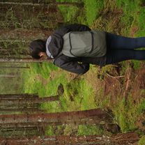
The recommended direction begins with a steep climb, where you will most likely need to push the bike. This option is chosen so you can then fully enjoy a long descent of over 20 km.
The climb starts along the Firii stream and lasts about an hour, depending on your pace. The effort is well rewarded by the summit views. Numerous roads might cause confusion, but navigation is simple: just follow the ridge for around 9 km. Do not forget: you are on a mountain ridge and summer storms can develop very quickly. Take care not to get caught out on the ridge!
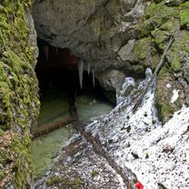
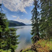
The descent from the ridge follows the red stripe trail marker and reaches Lake Vărășoaia, then Padiș. Be careful on this descent as gravel and mud may cause difficulties. There is a feed zone at the Padiș hut, and the second part of the descent is smoother.
created this 8 years ago


Route quality
Track
22.5 km
(47 %)
Quiet road
12.9 km
(27 %)
Paved
12.9 km
(27 %)
Unpaved
25.3 km
(53 %)
Gravel
17.7 km
(37 %)
Asphalt
11.5 km
(24 %)
Route highlights


Continue with Bikemap
You would like to ride 8. Pe platoul Cârligate or customize it for your own trip? Here is what you can do with this Bikemap route:
Free trial for 3 days, or one-time payment. More about Bikemap Premium.
Discover more Premium features.
Get Bikemap PremiumFrom our community
Open it in the app