

11. Satul Giurcuța de Sus
A cycling route starting in Beliş, Cluj County, Romania.
Overview
About this route
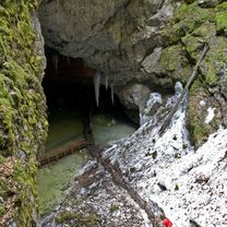
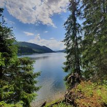
Lacul Fântânele este impresionant datorită suprafeței și amplasării. Unul din cele mai frumoase puncte de belvedere este la capătul acestui traseu. Din nou, navigarea nu o să fie o problemă deoarece există indicatoare spre sat. Din centrul așezări trebuie să urmați drumul paralel cu malul și apoi, prin pădure, ajungeți la o deschidere imensă care ajunge până la malul apei. Satul Giurcuța de Sus, pe lângă peisajul tipic Munților Apuseni, mai ascunde ceva deosebit. Așezarea a fost mutată pe dealuri la construirea barajului, iar zidurile bisericii vechi încă mai pot fi văzute când nivelul apei este scăzut.
- -:--
- Duration
- 14.6 km
- Distance
- 348 m
- Ascent
- 367 m
- Descent
- ---
- Avg. speed
- ---
- Max. altitude

Route photos


Route quality
Waytypes & surfaces along the route
Waytypes
Road
8.3 km
(57 %)
Quiet road
6.3 km
(43 %)
Surfaces
Paved
8.3 km
(57 %)
Unpaved
6.3 km
(43 %)
Asphalt
8.3 km
(57 %)
Gravel
6.3 km
(43 %)
Route highlights
Points of interest along the route

Point of interest after 1.1 km

Point of interest after 7.1 km
Continue with Bikemap
Use, edit, or download this cycling route
You would like to ride 11. Satul Giurcuța de Sus or customize it for your own trip? Here is what you can do with this Bikemap route:
Free features
- Save this route as favorite or in collections
- Copy & plan your own version of this route
- Sync your route with Garmin or Wahoo
Premium features
Free trial for 3 days, or one-time payment. More about Bikemap Premium.
- Navigate this route on iOS & Android
- Export a GPX / KML file of this route
- Create your custom printout (try it for free)
- Download this route for offline navigation
Discover more Premium features.
Get Bikemap PremiumFrom our community
Other popular routes starting in Beliş
 13. Cascada Răchițele (Vălul Miresei)
- Distance
- 23.3 km
- Ascent
- 551 m
- Descent
- 514 m
- Location
- Beliş, Cluj County, Romania
 3. Platoul Padiș
- Distance
- 101.3 km
- Ascent
- 1,670 m
- Descent
- 1,669 m
- Location
- Beliş, Cluj County, Romania
 belis cascada valul miresei
- Distance
- 37.6 km
- Ascent
- 956 m
- Descent
- 860 m
- Location
- Beliş, Cluj County, Romania
 SUP session on Fântânele Lake, Beliș, Cluj Romania
- Distance
- 8 km
- Ascent
- 112 m
- Descent
- 100 m
- Location
- Beliş, Cluj County, Romania
 19. Pădurea de brad după Ic-Ponor
- Distance
- 7.1 km
- Ascent
- 220 m
- Descent
- 173 m
- Location
- Beliş, Cluj County, Romania
 Beliş-Fântânele
- Distance
- 5.2 km
- Ascent
- 348 m
- Descent
- 389 m
- Location
- Beliş, Cluj County, Romania
 Maraton MTB/XCM Turul Lacului Belis 2016. Traseu Scurt
- Distance
- 23.8 km
- Ascent
- 668 m
- Descent
- 668 m
- Location
- Beliş, Cluj County, Romania
 bike tour through Bălcești
- Distance
- 14.5 km
- Ascent
- 212 m
- Descent
- 212 m
- Location
- Beliş, Cluj County, Romania
Open it in the app