14. Circuit cascada Răchițele
A cycling route starting in Mărgău, Cluj County, Romania.
Overview
About this route
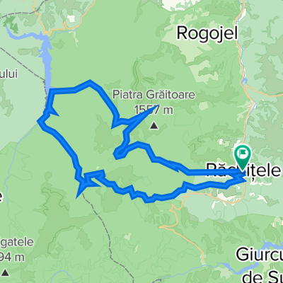
The best way to explore the Răchițele waterfall is by following this route, as after the waterfall it returns on a different trail, cresting the ridge of the village with the same name. The circuit is 13 km long and can be covered in 5-6 hours, depending on your pace. The trail is marked with a red dot and starts in the center of the mentioned village. The first section follows the road to the waterfall, then, a few hundred meters beyond, climbs through the forest towards the ridge, facing the imposing limestone massif. The total elevation gain is around 520 meters.
This route is accessible all year round, and the starting point is 18 km from Smida Park (Smida - Doda Pilii - Răchițele).
- -:--
- Duration
- 12.8 km
- Distance
- 529 m
- Ascent
- 528 m
- Descent
- ---
- Avg. speed
- ---
- Max. altitude
Route photos
Route quality
Waytypes & surfaces along the route
Waytypes
Track
7.7 km
(60 %)
Quiet road
5.1 km
(40 %)
Surfaces
Paved
4.4 km
(34 %)
Unpaved
8.5 km
(66 %)
Gravel
7.8 km
(61 %)
Asphalt
4.4 km
(34 %)
Ground
0.6 km
(5 %)
Route highlights
Points of interest along the route
Point of interest after 0 km
Point of interest after 5.7 km
Biserica de lemn Răchițele. Sursa pozei: Wikipedia
Continue with Bikemap
Use, edit, or download this cycling route
You would like to ride 14. Circuit cascada Răchițele or customize it for your own trip? Here is what you can do with this Bikemap route:
Free features
- Save this route as favorite or in collections
- Copy & plan your own version of this route
- Sync your route with Garmin or Wahoo
Premium features
Free trial for 3 days, or one-time payment. More about Bikemap Premium.
- Navigate this route on iOS & Android
- Export a GPX / KML file of this route
- Create your custom printout (try it for free)
- Download this route for offline navigation
Discover more Premium features.
Get Bikemap PremiumFrom our community
Other popular routes starting in Mărgău
- Cabana Dealu Rasinarilor - Vf Caciulata - Dealu Boti
- Distance
- 14.2 km
- Ascent
- 659 m
- Descent
- 664 m
- Location
- Mărgău, Cluj County, Romania
- Rachitele (Valea Stanciului) - PietreleAlbe - Rachitele
- Distance
- 23 km
- Ascent
- 782 m
- Descent
- 784 m
- Location
- Mărgău, Cluj County, Romania
- 14. Circuit cascada Răchițele
- Distance
- 12.8 km
- Ascent
- 529 m
- Descent
- 528 m
- Location
- Mărgău, Cluj County, Romania
- Rachitele - Doda Pilii - Dealu Botii- Rachitele
- Distance
- 30.8 km
- Ascent
- 712 m
- Descent
- 712 m
- Location
- Mărgău, Cluj County, Romania
- Circuit Rachitele
- Distance
- 26.1 km
- Ascent
- 844 m
- Descent
- 844 m
- Location
- Mărgău, Cluj County, Romania
- Valea Stanciului
- Distance
- 11.1 km
- Ascent
- 530 m
- Descent
- 110 m
- Location
- Mărgău, Cluj County, Romania
- Rachitele - Vladeasa
- Distance
- 17 km
- Ascent
- 1,173 m
- Descent
- 148 m
- Location
- Mărgău, Cluj County, Romania
- Rachitele - Lacul Dragan - Nimaiasa (Mediu)
- Distance
- 49.8 km
- Ascent
- 1,502 m
- Descent
- 1,503 m
- Location
- Mărgău, Cluj County, Romania
Open it in the app