3. Platoul Padiș
- 101.3 km
- 1,670 m
- 1,669 m
- Beliş, Cluj County, Romania
A cycling route starting in Beliş, Cluj County, Romania.
Overview
The GPS track is for the approach to the start of the circuit. Use the blue dot waymark to navigate the route.
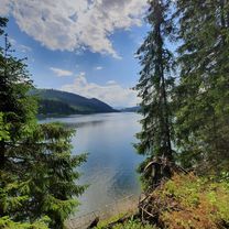
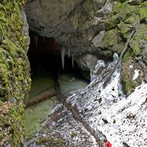
Both experts and tourists rate the karst features on this circuit as the most spectacular in Romania. The 300-meter-high walls of the fortresses are hard to grasp until you spot the fir trees clinging high above the slope. The mystery of the waters disappearing and reappearing multiple times only increases the urge to explore.
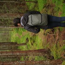
The blue dot waymark starts at Padiș cabin, leads to the Ponor spring, crosses Ponor clearing and reaches the Ponor Fortresses. Here, the route passes through Dolina I and Dolina III, then climbs up to the wooden balconies suspended above them. However, the elevation gain makes this hiking route tiring and dangerous. Also, there are no water sources in the higher zone. The circuit returns via Glăvoi and rejoins the starting point through the forest.
This route is accessible only in summer and under favorable weather conditions. The start point is located 16 km from Smida Park (Smida – Doda Pilii – Padiș). Approximate completion time is 6 hours.
created this 8 years ago
\"")
\"")
\"")
Route quality
Quiet road
11.4 km
(68 %)
Road
0.5 km
(3 %)
Undefined
4.9 km
(29 %)
Paved
4.9 km
(29 %)
Unpaved
11.9 km
(71 %)
Gravel
11.9 km
(71 %)
Asphalt
4.9 km
(29 %)
Route highlights
\"")
\"")
\"")
Continue with Bikemap
You would like to ride 16. Circuitul Cetățile Ponorului (Padiș) or customize it for your own trip? Here is what you can do with this Bikemap route:
Free trial for 3 days, or one-time payment. More about Bikemap Premium.
Discover more Premium features.
Get Bikemap PremiumFrom our community
Open it in the app