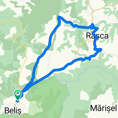
21. Poienița plantelor carnivore
- 4.7 km
- 137 m
- 137 m
- Beliş, Cluj County, Romania
A cycling route starting in Beliş, Cluj County, Romania.
Overview
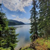
Another beautiful area is the forest bordering the access road from Smida to Giurcuța de Sus. In this location, you can reach it through the village, towards Doda Pilii, then climbing directly towards the forest or via the main road. We recommend taking one option on the way out and the other on the way back.
This recommended area can be combined with the first one for a longer circuit that also includes a visit to the village of Giurcuța de Sus. The duration of this circuit can be up to 6 hours.
created this 8 years ago


Route quality
Road
1.6 km
(53 %)
Track
0.9 km
(29 %)
Paved
1.6 km
(53 %)
Unpaved
0.5 km
(17 %)
Asphalt
1.6 km
(53 %)
Gravel
0.5 km
(17 %)
Undefined
0.9 km
(30 %)
Route highlights


Continue with Bikemap
You would like to ride 18. Pădurea de brad de la Smida or customize it for your own trip? Here is what you can do with this Bikemap route:
Free trial for 3 days, or one-time payment. More about Bikemap Premium.
Discover more Premium features.
Get Bikemap PremiumFrom our community
Open it in the app