Marin 1
A cycling route starting in Mill Valley, California, United States of America.
Overview
About this route
- -:--
- Duration
- 66.4 km
- Distance
- 1,234 m
- Ascent
- 1,235 m
- Descent
- ---
- Avg. speed
- ---
- Avg. speed
Route quality
Waytypes & surfaces along the route
Waytypes
Busy road
24.2 km
(36 %)
Quiet road
18.9 km
(28 %)
Surfaces
Paved
37.7 km
(57 %)
Unpaved
7.3 km
(11 %)
Asphalt
27.4 km
(41 %)
Paved (undefined)
10.3 km
(15 %)
Continue with Bikemap
Use, edit, or download this cycling route
You would like to ride Marin 1 or customize it for your own trip? Here is what you can do with this Bikemap route:
Free features
- Save this route as favorite or in collections
- Copy & plan your own version of this route
- Sync your route with Garmin or Wahoo
Premium features
Free trial for 3 days, or one-time payment. More about Bikemap Premium.
- Navigate this route on iOS & Android
- Export a GPX / KML file of this route
- Create your custom printout (try it for free)
- Download this route for offline navigation
Discover more Premium features.
Get Bikemap PremiumFrom our community
Other popular routes starting in Mill Valley
- Mill Valley Beerworks
- Distance
- 35.6 km
- Ascent
- 925 m
- Descent
- 936 m
- Location
- Mill Valley, California, United States of America
- Muir Beach & Tennessee Valley
- Distance
- 36.3 km
- Ascent
- 628 m
- Descent
- 632 m
- Location
- Mill Valley, California, United States of America
- L'Alpe d'Tamz
- Distance
- 34.9 km
- Ascent
- 896 m
- Descent
- 896 m
- Location
- Mill Valley, California, United States of America
- tam alpine dam loop
- Distance
- 50.6 km
- Ascent
- 841 m
- Descent
- 841 m
- Location
- Mill Valley, California, United States of America
- Fairfax Loop
- Distance
- 50.9 km
- Ascent
- 863 m
- Descent
- 852 m
- Location
- Mill Valley, California, United States of America
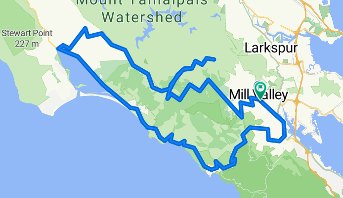
- Muir Beach and Tennessee Valley
- Distance
- 36.5 km
- Ascent
- 995 m
- Descent
- 999 m
- Location
- Mill Valley, California, United States of America
- Mill Valley Stinson Muir Beach Loop
- Distance
- 40.8 km
- Ascent
- 917 m
- Descent
- 916 m
- Location
- Mill Valley, California, United States of America
- Muir Woods Loop
- Distance
- 22.3 km
- Ascent
- 1,484 m
- Descent
- 1,481 m
- Location
- Mill Valley, California, United States of America
Open it in the app