Reschensee
A cycling route starting in Schluderns, Trentino-Alto Adige, Italy.
Overview
About this route
<p>
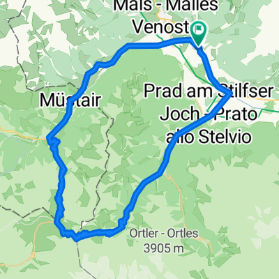
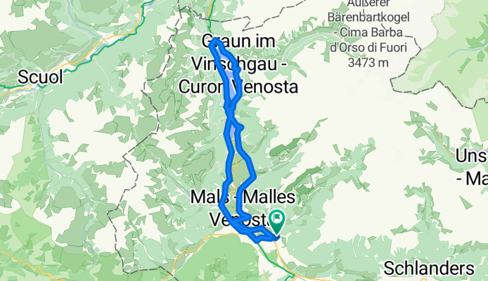
Loop tour to Resia Lake. Via Laatsch, Schleiss, Burgels Casoni di Fuori. Return via Dörfl and Planei to Schluders.</p>
Translated, show original (German)- -:--
- Duration
- 52.2 km
- Distance
- 747 m
- Ascent
- 748 m
- Descent
- ---
- Avg. speed
- ---
- Max. altitude
Route quality
Waytypes & surfaces along the route
Waytypes
Track
17.7 km
(34 %)
Quiet road
17.2 km
(33 %)
Surfaces
Paved
42.8 km
(82 %)
Unpaved
6.8 km
(13 %)
Asphalt
42.8 km
(82 %)
Loose gravel
4.2 km
(8 %)
Continue with Bikemap
Use, edit, or download this cycling route
You would like to ride Reschensee or customize it for your own trip? Here is what you can do with this Bikemap route:
Free features
- Save this route as favorite or in collections
- Copy & plan your own version of this route
- Sync your route with Garmin or Wahoo
Premium features
Free trial for 3 days, or one-time payment. More about Bikemap Premium.
- Navigate this route on iOS & Android
- Export a GPX / KML file of this route
- Create your custom printout (try it for free)
- Download this route for offline navigation
Discover more Premium features.
Get Bikemap PremiumFrom our community
Other popular routes starting in Schluderns
- Rundtour Lasa kurz
- Distance
- 19.1 km
- Ascent
- 97 m
- Descent
- 97 m
- Location
- Schluderns, Trentino-Alto Adige, Italy
- Zugtrail - Nordseite
- Distance
- 37.5 km
- Ascent
- 699 m
- Descent
- 958 m
- Location
- Schluderns, Trentino-Alto Adige, Italy
- 4. Etappe 20.07.2021 Schluderns nach Lana
- Distance
- 66.1 km
- Ascent
- 90 m
- Descent
- 734 m
- Location
- Schluderns, Trentino-Alto Adige, Italy
- Rundtour Burgusio
- Distance
- 18.7 km
- Ascent
- 330 m
- Descent
- 331 m
- Location
- Schluderns, Trentino-Alto Adige, Italy
- 65 Schluderns-Stilfserjoch-Umbrail-Schluderns
- Distance
- 65.1 km
- Ascent
- 1,883 m
- Descent
- 1,885 m
- Location
- Schluderns, Trentino-Alto Adige, Italy
- Über den Reschenpass zum Arlberg
- Distance
- 97.6 km
- Ascent
- 1,453 m
- Descent
- 1,072 m
- Location
- Schluderns, Trentino-Alto Adige, Italy
- Reschensee
- Distance
- 52.2 km
- Ascent
- 747 m
- Descent
- 748 m
- Location
- Schluderns, Trentino-Alto Adige, Italy
- Schluderns bis Bassano del Grappa
- Distance
- 244.4 km
- Ascent
- 697 m
- Descent
- 1,519 m
- Location
- Schluderns, Trentino-Alto Adige, Italy
Open it in the app