

Overview
About this route
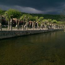
Loveley route around Lac Montbel with 3 short climbs and an off road steep descent down at track to join the road circuit up. Best done when very dry, the track is clay and clogs your bike up when wet.
- -:--
- Duration
- 26.9 km
- Distance
- 474 m
- Ascent
- 475 m
- Descent
- ---
- Avg. speed
- ---
- Max. altitude

Part of
Routes around Le Peyrat
11 stages
Route quality
Waytypes & surfaces along the route
Waytypes
Road
11.6 km
(43 %)
Quiet road
11 km
(41 %)
Surfaces
Paved
0.5 km
(2 %)
Unpaved
1.6 km
(6 %)
Unpaved (undefined)
1.6 km
(6 %)
Paved (undefined)
0.5 km
(2 %)
Undefined
24.7 km
(92 %)
Continue with Bikemap
Use, edit, or download this cycling route
You would like to ride Around Montbel or customize it for your own trip? Here is what you can do with this Bikemap route:
Free features
- Save this route as favorite or in collections
- Copy & plan your own version of this route
- Sync your route with Garmin or Wahoo
Premium features
Free trial for 3 days, or one-time payment. More about Bikemap Premium.
- Navigate this route on iOS & Android
- Export a GPX / KML file of this route
- Create your custom printout (try it for free)
- Download this route for offline navigation
Discover more Premium features.
Get Bikemap PremiumFrom our community
Other popular routes starting in Bélesta
 Le Peyrat - Col du Pradel
- Distance
- 108.3 km
- Ascent
- 1,823 m
- Descent
- 1,823 m
- Location
- Bélesta, Occitanie, France
 44k Le Peyrat-Chalabre-Col du Tuquet - Puivert
- Distance
- 44.3 km
- Ascent
- 612 m
- Descent
- 615 m
- Location
- Bélesta, Occitanie, France
 Le Peyrat-Espezel-Puivert 50k
- Distance
- 56.2 km
- Ascent
- 635 m
- Descent
- 632 m
- Location
- Bélesta, Occitanie, France
 2014 Ride Day 46 - Bélesta Circle through Puivert, Castelreng, Chalabre, and Lesparrou
- Distance
- 81.6 km
- Ascent
- 1,153 m
- Descent
- 1,157 m
- Location
- Bélesta, Occitanie, France
 Etappe 5 : Belesta - Ax-les-Thermes direct
- Distance
- 45.4 km
- Ascent
- 1,507 m
- Descent
- 1,267 m
- Location
- Bélesta, Occitanie, France
 Etape 5 : Belesta - Ax-les-Thermes via Montsegur
- Distance
- 78 km
- Ascent
- 2,381 m
- Descent
- 2,148 m
- Location
- Bélesta, Occitanie, France
 Around Montbel
- Distance
- 26.9 km
- Ascent
- 474 m
- Descent
- 475 m
- Location
- Bélesta, Occitanie, France
 Plateau de Sault et Port de Pailhères (Ariège 2017)
- Distance
- 73.8 km
- Ascent
- 2,067 m
- Descent
- 2,067 m
- Location
- Bélesta, Occitanie, France
Open it in the app