

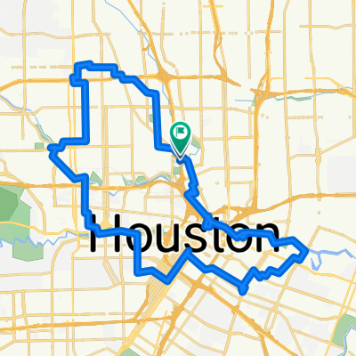
Taco Ride
A cycling route starting in Houston, Texas, United States.
Overview
About this route
- -:--
- Duration
- 12.9 km
- Distance
- 60 m
- Ascent
- 57 m
- Descent
- ---
- Avg. speed
- ---
- Max. altitude

Route quality
Waytypes & surfaces along the route
Waytypes
Quiet road
6.5 km
(51 %)
Road
3.9 km
(30 %)
Surfaces
Paved
6.6 km
(51 %)
Asphalt
6.5 km
(50 %)
Concrete
0.1 km
(<1 %)
Continue with Bikemap
Use, edit, or download this cycling route
You would like to ride Taco Ride or customize it for your own trip? Here is what you can do with this Bikemap route:
Free features
- Save this route as favorite or in collections
- Copy & plan your own version of this route
- Sync your route with Garmin or Wahoo
Premium features
Free trial for 3 days, or one-time payment. More about Bikemap Premium.
- Navigate this route on iOS & Android
- Export a GPX / KML file of this route
- Create your custom printout (try it for free)
- Download this route for offline navigation
Discover more Premium features.
Get Bikemap PremiumFrom our community
Other popular routes starting in Houston
 UH Downtown to Shepard
- Distance
- 15.9 km
- Ascent
- 179 m
- Descent
- 177 m
- Location
- Houston, Texas, United States
 Mardi Gras Love Yourself 24k
- Distance
- 23.7 km
- Ascent
- 109 m
- Descent
- 110 m
- Location
- Houston, Texas, United States
 Memorial Park Loop
- Distance
- 17.9 km
- Ascent
- 94 m
- Descent
- 88 m
- Location
- Houston, Texas, United States
 Heights loop
- Distance
- 40.2 km
- Ascent
- 89 m
- Descent
- 87 m
- Location
- Houston, Texas, United States
 3-24 Bike Ride
- Distance
- 11.3 km
- Ascent
- 20 m
- Descent
- 18 m
- Location
- Houston, Texas, United States
 Whitney St, Houston to S Braeswood Blvd, Houston
- Distance
- 17.7 km
- Ascent
- 35 m
- Descent
- 34 m
- Location
- Houston, Texas, United States
 bike tour through Houston
- Distance
- 10.3 km
- Ascent
- 39 m
- Descent
- 39 m
- Location
- Houston, Texas, United States
 eado to spotts park
- Distance
- 6.5 km
- Ascent
- 106 m
- Descent
- 111 m
- Location
- Houston, Texas, United States
Open it in the app