

Trail Running 5k
A cycling route starting in Otavalo, Imbabura, Ecuador.
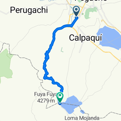
Overview
About this route
Trail Running nocturno 5k Recomendación Uso de Calentador..Los competidores deberán realizar todo el recorrido juntos, esto confirmando el paso en cada PM, requisito obligatorio mínimo una linterna
- -:--
- Duration
- 5.4 km
- Distance
- 328 m
- Ascent
- 323 m
- Descent
- ---
- Avg. speed
- ---
- Max. altitude

Continue with Bikemap
Use, edit, or download this cycling route
You would like to ride Trail Running 5k or customize it for your own trip? Here is what you can do with this Bikemap route:
Free features
- Save this route as favorite or in collections
- Copy & plan your own version of this route
- Sync your route with Garmin or Wahoo
Premium features
Free trial for 3 days, or one-time payment. More about Bikemap Premium.
- Navigate this route on iOS & Android
- Export a GPX / KML file of this route
- Create your custom printout (try it for free)
- Download this route for offline navigation
Discover more Premium features.
Get Bikemap PremiumFrom our community
Other popular routes starting in Otavalo
 A la cascada de Chirisacha
- Distance
- 23.1 km
- Ascent
- 689 m
- Descent
- 688 m
- Location
- Otavalo, Imbabura, Ecuador
 Otavalo (Lagunas de mojanda, Cochasqui)
- Distance
- 16.4 km
- Ascent
- 1,208 m
- Descent
- 25 m
- Location
- Otavalo, Imbabura, Ecuador
 Vuelta al Imbabura
- Distance
- 48.5 km
- Ascent
- 1,136 m
- Descent
- 1,139 m
- Location
- Otavalo, Imbabura, Ecuador
 Fuya Fuya
- Distance
- 24.8 km
- Ascent
- 1,310 m
- Descent
- 284 m
- Location
- Otavalo, Imbabura, Ecuador
 otavalo quicocha
- Distance
- 37.9 km
- Ascent
- 922 m
- Descent
- 562 m
- Location
- Otavalo, Imbabura, Ecuador
 Trail Runinng 8k
- Distance
- 7.2 km
- Ascent
- 379 m
- Descent
- 372 m
- Location
- Otavalo, Imbabura, Ecuador
 Mojanda Cerro Negro
- Distance
- 16.4 km
- Ascent
- 816 m
- Descent
- 817 m
- Location
- Otavalo, Imbabura, Ecuador
 De Callecompetencia otavalo Luis Alberto De La Torre 1412, Otavalo a Calle Luis Alberto De La Torre 1412, Otavalo
- Distance
- 15.6 km
- Ascent
- 276 m
- Descent
- 0 m
- Location
- Otavalo, Imbabura, Ecuador
Open it in the app