

Aufnahme vom 1. 7. 2017, 14:24
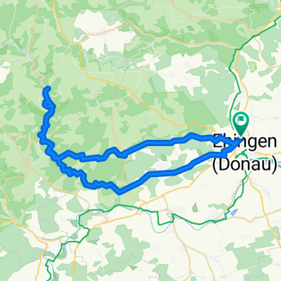
A cycling route starting in Ehingen, Baden-Wurttemberg, Germany.
Overview
About this route
- -:--
- Duration
- 37.4 km
- Distance
- 70 m
- Ascent
- 108 m
- Descent
- ---
- Avg. speed
- ---
- Max. altitude

Route quality
Waytypes & surfaces along the route
Waytypes
Track
9.9 km
(26 %)
Pedestrian area
7.7 km
(21 %)
Surfaces
Paved
32.5 km
(87 %)
Unpaved
0.2 km
(<1 %)
Asphalt
26.3 km
(70 %)
Paving stones
5 km
(13 %)
Route highlights
Points of interest along the route
Point of interest after 33.8 km
Continue with Bikemap
Use, edit, or download this cycling route
You would like to ride Aufnahme vom 1. 7. 2017, 14:24 or customize it for your own trip? Here is what you can do with this Bikemap route:
Free features
- Save this route as favorite or in collections
- Copy & plan your own version of this route
- Sync your route with Garmin or Wahoo
Premium features
Free trial for 3 days, or one-time payment. More about Bikemap Premium.
- Navigate this route on iOS & Android
- Export a GPX / KML file of this route
- Create your custom printout (try it for free)
- Download this route for offline navigation
Discover more Premium features.
Get Bikemap PremiumFrom our community
Other popular routes starting in Ehingen
 Aufnahme vom 1. 7. 2017, 14:24
- Distance
- 37.4 km
- Ascent
- 70 m
- Descent
- 108 m
- Location
- Ehingen, Baden-Wurttemberg, Germany
 Ehingen - Obermarchtal - Bussen - Ehingen
- Distance
- 72.2 km
- Ascent
- 397 m
- Descent
- 402 m
- Location
- Ehingen, Baden-Wurttemberg, Germany
 From Ehingen (Donau) to Sigmaringen
- Distance
- 68.5 km
- Ascent
- 535 m
- Descent
- 470 m
- Location
- Ehingen, Baden-Wurttemberg, Germany
 201407-04 Donauradweg Ehingen - Blaubeuren - Leipheim
- Distance
- 64.1 km
- Ascent
- 111 m
- Descent
- 161 m
- Location
- Ehingen, Baden-Wurttemberg, Germany
 Ehingen - Konstanz
- Distance
- 124 km
- Ascent
- 474 m
- Descent
- 607 m
- Location
- Ehingen, Baden-Wurttemberg, Germany
 100km Tour
- Distance
- 99.2 km
- Ascent
- 1,422 m
- Descent
- 1,412 m
- Location
- Ehingen, Baden-Wurttemberg, Germany
 Ehingen - Oberschwäbisches Hügelland
- Distance
- 71.6 km
- Ascent
- 713 m
- Descent
- 714 m
- Location
- Ehingen, Baden-Wurttemberg, Germany
 Ehingen - Bichishausen
- Distance
- 59.2 km
- Ascent
- 462 m
- Descent
- 466 m
- Location
- Ehingen, Baden-Wurttemberg, Germany
Open it in the app