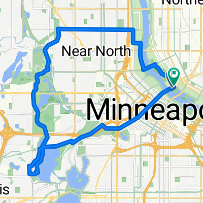
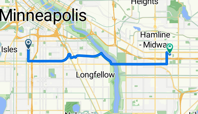
B2B00212 55404>55104 viaMidtownGreenway/wRiver/LakeSt.Marshall/Hamline
A cycling route starting in Minneapolis, Minnesota, United States of America.
Overview
About this route
Go south on Nicollet to the Midtown Greenway Bike Trail. Turn left (east) and follow the trail. At 28th Street you can either continue on the bike trail and cross Hiawatha Avenue using the cool Martin Sabo Bridge (beautiful at night) or you can turn right at 28th Street and cross Hiawatha at the traffic light. Turn right and continue on West River Pkwy. either on the bike path or road to the Lake Street Bridge. Cross the Lake Street Bridge and continue on what has now become Marshall Avenue in St. Paul. Take Marshall up the hill and continue until you reach Hamline Avenue.Turn left on Hamline and continue on Hamline to University Avenue. Turn right on University Avenue one block to Syndicate St. N. Turn right at Syndicate to your destination.
- -:--
- Duration
- 12.4 km
- Distance
- 47 m
- Ascent
- 35 m
- Descent
- ---
- Avg. speed
- 279 m
- Avg. speed
Route quality
Waytypes & surfaces along the route
Waytypes
Cycleway
5.5 km
(44 %)
Road
4.8 km
(39 %)
Surfaces
Paved
10.7 km
(87 %)
Asphalt
9.4 km
(76 %)
Paved (undefined)
1.2 km
(10 %)
Route highlights
Points of interest along the route
Point of interest after 3.5 km
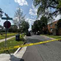
At this point you can either turn right at E. 28th Street and cross Hiawatha at the stop lights or continue on the bike path using the new Martin Sabo bridge.
Continue with Bikemap
Use, edit, or download this cycling route
You would like to ride B2B00212 55404>55104 viaMidtownGreenway/wRiver/LakeSt.Marshall/Hamline or customize it for your own trip? Here is what you can do with this Bikemap route:
Free features
- Save this route as favorite or in collections
- Copy & plan your own version of this route
- Sync your route with Garmin or Wahoo
Premium features
Free trial for 3 days, or one-time payment. More about Bikemap Premium.
- Navigate this route on iOS & Android
- Export a GPX / KML file of this route
- Create your custom printout (try it for free)
- Download this route for offline navigation
Discover more Premium features.
Get Bikemap PremiumFrom our community
Other popular routes starting in Minneapolis
- 1500–1562 Spruce Pl, Minneapolis to 1512 Spruce Pl, Minneapolis
- Distance
- 28.4 km
- Ascent
- 133 m
- Descent
- 132 m
- Location
- Minneapolis, Minnesota, United States of America
- Tour de Luce
- Distance
- 100 km
- Ascent
- 620 m
- Descent
- 619 m
- Location
- Minneapolis, Minnesota, United States of America
- 1512 Spruce Pl, Minneapolis to 1512 Spruce Pl, Minneapolis
- Distance
- 27.3 km
- Ascent
- 123 m
- Descent
- 123 m
- Location
- Minneapolis, Minnesota, United States of America
- S Sixth St, Minneapolis to Spruce Pl, Minneapolis
- Distance
- 1.7 km
- Ascent
- 6 m
- Descent
- 21 m
- Location
- Minneapolis, Minnesota, United States of America
- 34 Spruce Pl, Minneapolis to Loring Park, Minneapolis
- Distance
- 15.3 km
- Ascent
- 62 m
- Descent
- 63 m
- Location
- Minneapolis, Minnesota, United States of America
- East/West River Ride
- Distance
- 22.6 km
- Ascent
- 216 m
- Descent
- 217 m
- Location
- Minneapolis, Minnesota, United States of America
- TCAC Cedar Lake Loop
- Distance
- 15.9 km
- Ascent
- 55 m
- Descent
- 54 m
- Location
- Minneapolis, Minnesota, United States of America
- 1512 Spruce Pl, Minneapolis to 312 Central Ave SE, Minneapolis
- Distance
- 27.4 km
- Ascent
- 147 m
- Descent
- 142 m
- Location
- Minneapolis, Minnesota, United States of America