Attenkirchen Ampertour
A cycling route starting in Attenkirchen, Bavaria, Germany.
Overview
About this route
Route as described in Tours 1 and 2 up to Thalham, there stay on the paved road and continue via Walkertshausen, Osterimbach, Flitzing to Zolling. Take the signposted route to the Amper bridge, cross the B 301 here and enter the road towards Moos/Haindlfing near Freising. Ride the paved road through Moos to Haindlfing, cross the district road FS 8 there and cycle on the road towards Garten until just before Unterberg. On open stretch, turn right and go through the Ampermoos towards Palzing to the town centre (it is signposted). From there take the steep climb towards Wolfersdorf. At the top just behind Palzing follow the signpost left towards Jägersdorf, after two-thirds of the route turn right to Wölfing up to Wolfersdorf. From Wolfersdorf to the FS 27 in Berghaselbach and from there on the direct route to Attenkirchen. Or alternatively the route from Berghaselbach back to Attenkirchen as described in Tour 1.
- -:--
- Duration
- 25 km
- Distance
- 195 m
- Ascent
- 211 m
- Descent
- ---
- Avg. speed
- 518 m
- Max. altitude
Route quality
Waytypes & surfaces along the route
Waytypes
Quiet road
14.8 km
(59 %)
Road
6.8 km
(27 %)
Surfaces
Paved
22 km
(88 %)
Unpaved
0.5 km
(2 %)
Asphalt
20.5 km
(82 %)
Paved (undefined)
1.5 km
(6 %)
Route highlights
Points of interest along the route

Point of interest after 0 km
Gasthaus „Alter Wirt“ Zum Katti Bräu Hauptstraße 5 Tel. 0049 8168 997076 www.kathi-braeu.de

Accommodation after 2.8 km
Hotel Biergaren Restaurant am See Thalhamer Hof, Waldstraße 14, 85395 Thalham, Tel. 08168 90820, www.thalhamer-hof.de

Accommodation after 7.2 km
Gasthaus Hörhammer „Alter Wirt“ Freisinger Str. 4 85406 Zolling Tel. 0049 8167 692899

Photo after 20.5 km
Kapelle Klausenberg Hier an diesem Ort wurde 1709 neben der bestehenden Nikolauskapelle eine Klause errichtet. In der Säkularisationszeit musste die Klause 1804 geschlossen werden.

Photo after 22.3 km
Straußenfarm Familie Hiereth Badendorf 3, 85395 Wolfersdorf Tel. 0049 1702150749 Öffnungszeiten: Mo.-Fr. 18.00-20.00 Sa. U. So. 10.00-18.00

Accommodation after 23.3 km
Hotel-Gasthaus Ostermeier, Dorfstraße 8, 85395 Attenkirchen/Gütlsdorf Te. 0049 8168 243 www.gasthaus-ostermeier.de

Accommodation after 24.9 km
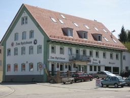
Hotel-Restaurant „Zum Spitzbuam“ Hauptstraße 1, 85395 Attenkirchen 0049 8168 999316 www.zumspitzbuam.de
Continue with Bikemap
Use, edit, or download this cycling route
You would like to ride Attenkirchen Ampertour or customize it for your own trip? Here is what you can do with this Bikemap route:
Free features
- Save this route as favorite or in collections
- Copy & plan your own version of this route
- Sync your route with Garmin or Wahoo
Premium features
Free trial for 3 days, or one-time payment. More about Bikemap Premium.
- Navigate this route on iOS & Android
- Export a GPX / KML file of this route
- Create your custom printout (try it for free)
- Download this route for offline navigation
Discover more Premium features.
Get Bikemap PremiumFrom our community
Other popular routes starting in Attenkirchen
 Rundum Moosburg
- Distance
- 44.8 km
- Ascent
- 245 m
- Descent
- 243 m
- Location
- Attenkirchen, Bavaria, Germany
 Amelie Oberappersdorf - Haag-Zolling-Attenkirchen
- Distance
- 29.3 km
- Ascent
- 804 m
- Descent
- 817 m
- Location
- Attenkirchen, Bavaria, Germany
 Radrunde durch Zolling 30.8.17
- Distance
- 15.7 km
- Ascent
- 112 m
- Descent
- 124 m
- Location
- Attenkirchen, Bavaria, Germany
 Cabtour
- Distance
- 469.7 km
- Ascent
- 1,201 m
- Descent
- 1,201 m
- Location
- Attenkirchen, Bavaria, Germany
 Attenkirchen Hopfentour CLONED FROM ROUTE 407729
- Distance
- 23.3 km
- Ascent
- 210 m
- Descent
- 210 m
- Location
- Attenkirchen, Bavaria, Germany
 kleine Runde
- Distance
- 23.2 km
- Ascent
- 165 m
- Descent
- 158 m
- Location
- Attenkirchen, Bavaria, Germany
 M2a: Attenkirchen - Waidhofen 70,8km 480hm
- Distance
- 70.7 km
- Ascent
- 566 m
- Descent
- 655 m
- Location
- Attenkirchen, Bavaria, Germany
 Saale 2: Attenkirchen - Regensburg-Mariaort, Gasthof Krieger, 86,6km, 179hm
- Distance
- 87.2 km
- Ascent
- 179 m
- Descent
- 364 m
- Location
- Attenkirchen, Bavaria, Germany
Open it in the app


